You are here: Home > Network List > TA - USArray Transportable Network (new EarthScope stations) Stations List
> Station C16K Lisburne Hills, AK, USA > Earthquake Result Viewer
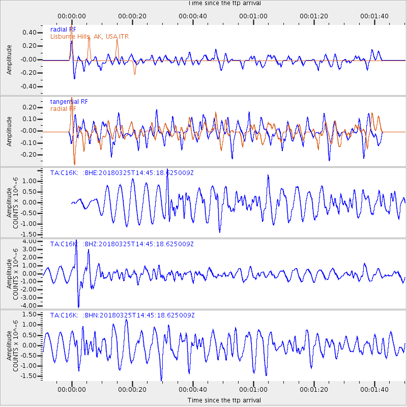
C16K Lisburne Hills, AK, USA - Earthquake Result Viewer
*The percent match for this event was below the threshold and hence no stack was calculated.
| Earthquake location: |
Southeast Of Honshu, Japan |
| Earthquake latitude/longitude: |
32.6/140.6 |
| Earthquake time(UTC): |
2018/03/25 (084) 14:37:23 GMT |
| Earthquake Depth: |
51 km |
| Earthquake Magnitude: |
5.7 Mww |
| Earthquake Catalog/Contributor: |
NEIC PDE/us |
|
| Network: |
TA USArray Transportable Network (new EarthScope stations) |
| Station: |
C16K Lisburne Hills, AK, USA |
| Lat/Lon: |
68.27 N/165.34 W |
| Elevation: |
102 m |
|
| Distance: |
47.0 deg |
| Az: |
24.335 deg |
| Baz: |
249.105 deg |
| Ray Param: |
$rayparam |
*The percent match for this event was below the threshold and hence was not used in the summary stack. |
|
| Radial Match: |
71.90621 % |
| Radial Bump: |
400 |
| Transverse Match: |
72.72851 % |
| Transverse Bump: |
400 |
| SOD ConfigId: |
13570011 |
| Insert Time: |
2019-04-30 00:24:33.650 +0000 |
| GWidth: |
2.5 |
| Max Bumps: |
400 |
| Tol: |
0.001 |
|
Signal To Noise
| Channel | StoN | STA | LTA |
| TA:C16K: :BHZ:20180325T14:45:18.625009Z | 3.5054812 | 1.7963038E-6 | 5.1242716E-7 |
| TA:C16K: :BHN:20180325T14:45:18.625009Z | 1.1301504 | 5.701438E-7 | 5.044849E-7 |
| TA:C16K: :BHE:20180325T14:45:18.625009Z | 1.0945954 | 5.8843295E-7 | 5.375803E-7 |
| Arrivals |
| Ps | |
| PpPs | |
| PsPs/PpSs | |


