You are here: Home > Network List > TA - USArray Transportable Network (new EarthScope stations) Stations List
> Station I23K Minto, Yukon-Koyukuk, AK, USA > Earthquake Result Viewer
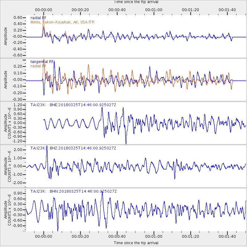
I23K Minto, Yukon-Koyukuk, AK, USA - Earthquake Result Viewer
*The percent match for this event was below the threshold and hence no stack was calculated.
| Earthquake location: |
Southeast Of Honshu, Japan |
| Earthquake latitude/longitude: |
32.6/140.6 |
| Earthquake time(UTC): |
2018/03/25 (084) 14:37:23 GMT |
| Earthquake Depth: |
51 km |
| Earthquake Magnitude: |
5.7 Mww |
| Earthquake Catalog/Contributor: |
NEIC PDE/us |
|
| Network: |
TA USArray Transportable Network (new EarthScope stations) |
| Station: |
I23K Minto, Yukon-Koyukuk, AK, USA |
| Lat/Lon: |
65.15 N/149.36 W |
| Elevation: |
149 m |
|
| Distance: |
52.6 deg |
| Az: |
30.011 deg |
| Baz: |
267.463 deg |
| Ray Param: |
$rayparam |
*The percent match for this event was below the threshold and hence was not used in the summary stack. |
|
| Radial Match: |
64.715454 % |
| Radial Bump: |
400 |
| Transverse Match: |
64.30421 % |
| Transverse Bump: |
397 |
| SOD ConfigId: |
13570011 |
| Insert Time: |
2019-04-30 00:25:41.424 +0000 |
| GWidth: |
2.5 |
| Max Bumps: |
400 |
| Tol: |
0.001 |
|
Signal To Noise
| Channel | StoN | STA | LTA |
| TA:I23K: :BHZ:20180325T14:46:00.925027Z | 4.2875457 | 9.184148E-7 | 2.1420524E-7 |
| TA:I23K: :BHN:20180325T14:46:00.925027Z | 1.2406863 | 2.7692013E-7 | 2.2319914E-7 |
| TA:I23K: :BHE:20180325T14:46:00.925027Z | 2.3306105 | 4.861427E-7 | 2.0859028E-7 |
| Arrivals |
| Ps | |
| PpPs | |
| PsPs/PpSs | |


