You are here: Home > Network List > TA - USArray Transportable Network (new EarthScope stations) Stations List
> Station J19K Poorman, AK, USA > Earthquake Result Viewer
J19K Poorman, AK, USA - Earthquake Result Viewer
| Earthquake location: |
Southeast Of Honshu, Japan |
| Earthquake latitude/longitude: |
32.6/140.6 |
| Earthquake time(UTC): |
2018/03/25 (084) 14:37:23 GMT |
| Earthquake Depth: |
51 km |
| Earthquake Magnitude: |
5.7 Mww |
| Earthquake Catalog/Contributor: |
NEIC PDE/us |
|
| Network: |
TA USArray Transportable Network (new EarthScope stations) |
| Station: |
J19K Poorman, AK, USA |
| Lat/Lon: |
63.99 N/155.62 W |
| Elevation: |
389 m |
|
| Distance: |
49.8 deg |
| Az: |
31.189 deg |
| Baz: |
262.554 deg |
| Ray Param: |
0.06836678 |
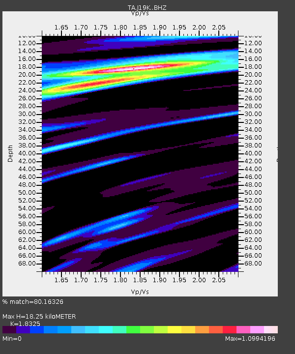
| Estimated Moho Depth: |
18.25 km |
| Estimated Crust Vp/Vs: |
1.83 |
| Assumed Crust Vp: |
6.438 km/s |
| Estimated Crust Vs: |
3.513 km/s |
| Estimated Crust Poisson's Ratio: |
0.29 |
|
| Radial Match: |
80.16326 % |
| Radial Bump: |
400 |
| Transverse Match: |
60.631187 % |
| Transverse Bump: |
342 |
| SOD ConfigId: |
13570011 |
| Insert Time: |
2019-04-30 00:25:48.602 +0000 |
| GWidth: |
2.5 |
| Max Bumps: |
400 |
| Tol: |
0.001 |
|

Signal To Noise
| Channel | StoN | STA | LTA |
| TA:J19K: :BHZ:20180325T14:45:40.025002Z | 5.677964 | 9.802925E-7 | 1.7264858E-7 |
| TA:J19K: :BHN:20180325T14:45:40.025002Z | 1.4785378 | 3.6967043E-7 | 2.5002433E-7 |
| TA:J19K: :BHE:20180325T14:45:40.025002Z | 2.5133018 | 5.809942E-7 | 2.3116769E-7 |
| Arrivals |
| Ps | 2.5 SECOND |
| PpPs | 7.6 SECOND |
| PsPs/PpSs | 10 SECOND |


