You are here: Home > Network List > IW - Intermountain West Stations List
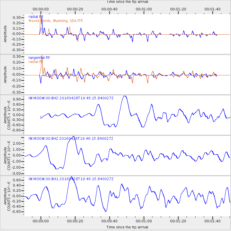
> Station MOOW Moose Ponds, Wyoming, USA > Earthquake Result Viewer
MOOW Moose Ponds, Wyoming, USA - Earthquake Result Viewer
| Earthquake location: |
Vanuatu Islands |
| Earthquake latitude/longitude: |
-16.1/167.3 |
| Earthquake time(UTC): |
2016/04/28 (119) 19:33:27 GMT |
| Earthquake Depth: |
35 km |
| Earthquake Magnitude: |
7.0 MO |
| Earthquake Catalog/Contributor: |
NEIC PDE/NEIC ALERT |
|
| Network: |
IW Intermountain West |
| Station: |
MOOW Moose Ponds, Wyoming, USA |
| Lat/Lon: |
43.75 N/110.74 W |
| Elevation: |
2128 m |
|
| Distance: |
95.3 deg |
| Az: |
46.1 deg |
| Baz: |
252.901 deg |
| Ray Param: |
0.04081036 |
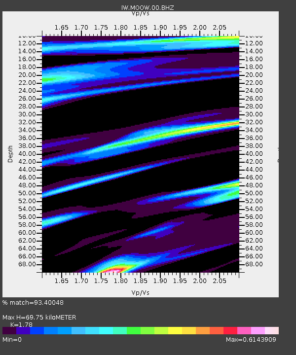
| Estimated Moho Depth: |
69.75 km |
| Estimated Crust Vp/Vs: |
1.78 |
| Assumed Crust Vp: |
6.207 km/s |
| Estimated Crust Vs: |
3.487 km/s |
| Estimated Crust Poisson's Ratio: |
0.27 |
|
| Radial Match: |
93.40048 % |
| Radial Bump: |
400 |
| Transverse Match: |
87.41292 % |
| Transverse Bump: |
400 |
| SOD ConfigId: |
1475611 |
| Insert Time: |
2016-05-12 20:04:35.046 +0000 |
| GWidth: |
2.5 |
| Max Bumps: |
400 |
| Tol: |
0.001 |
|
Signal To Noise
| Channel | StoN | STA | LTA |
| IW:MOOW:00:BHZ:20160428T19:46:15.840027Z | 10.851138 | 1.061697E-6 | 9.7842005E-8 |
| IW:MOOW:00:BH1:20160428T19:46:15.840027Z | 3.621288 | 2.4665857E-7 | 6.8113486E-8 |
| IW:MOOW:00:BH2:20160428T19:46:15.840027Z | 5.1000514 | 3.7569075E-7 | 7.366411E-8 |
| Arrivals |
| Ps | 8.9 SECOND |
| PpPs | 31 SECOND |
| PsPs/PpSs | 40 SECOND |


