You are here: Home > Network List > TA - USArray Transportable Network (new EarthScope stations) Stations List
> Station R33M Jennings River, BC, CAN > Earthquake Result Viewer
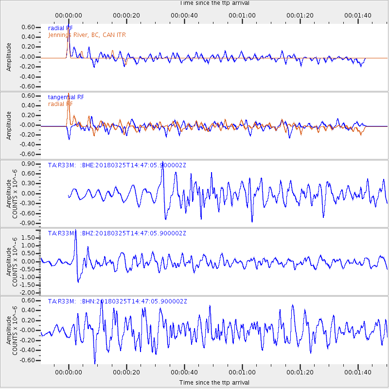
R33M Jennings River, BC, CAN - Earthquake Result Viewer
*The percent match for this event was below the threshold and hence no stack was calculated.
| Earthquake location: |
Southeast Of Honshu, Japan |
| Earthquake latitude/longitude: |
32.6/140.6 |
| Earthquake time(UTC): |
2018/03/25 (084) 14:37:23 GMT |
| Earthquake Depth: |
51 km |
| Earthquake Magnitude: |
5.7 Mww |
| Earthquake Catalog/Contributor: |
NEIC PDE/us |
|
| Network: |
TA USArray Transportable Network (new EarthScope stations) |
| Station: |
R33M Jennings River, BC, CAN |
| Lat/Lon: |
59.39 N/130.97 W |
| Elevation: |
1437 m |
|
| Distance: |
61.8 deg |
| Az: |
35.482 deg |
| Baz: |
286.749 deg |
| Ray Param: |
$rayparam |
*The percent match for this event was below the threshold and hence was not used in the summary stack. |
|
| Radial Match: |
68.64071 % |
| Radial Bump: |
400 |
| Transverse Match: |
64.20123 % |
| Transverse Bump: |
400 |
| SOD ConfigId: |
13570011 |
| Insert Time: |
2019-04-30 00:26:46.283 +0000 |
| GWidth: |
2.5 |
| Max Bumps: |
400 |
| Tol: |
0.001 |
|
Signal To Noise
| Channel | StoN | STA | LTA |
| TA:R33M: :BHZ:20180325T14:47:05.900002Z | 7.3542285 | 8.104473E-7 | 1.1020155E-7 |
| TA:R33M: :BHN:20180325T14:47:05.900002Z | 0.8312017 | 1.5569154E-7 | 1.8730897E-7 |
| TA:R33M: :BHE:20180325T14:47:05.900002Z | 3.3324172 | 4.7205083E-7 | 1.4165417E-7 |
| Arrivals |
| Ps | |
| PpPs | |
| PsPs/PpSs | |


