You are here: Home > Network List > CI - Caltech Regional Seismic Network Stations List
> Station JCS Julian Camp Stevens, California, USA > Earthquake Result Viewer
JCS Julian Camp Stevens, California, USA - Earthquake Result Viewer

| Earthquake location: |
South Of Mariana Islands |
| Earthquake latitude/longitude: |
12.7/145.0 |
| Earthquake time(UTC): |
2001/10/12 (285) 15:02:16 GMT |
| Earthquake Depth: |
37 km |
| Earthquake Magnitude: |
6.7 MB, 7.3 MS, 7.0 MW, 6.9 MW |
| Earthquake Catalog/Contributor: |
WHDF/NEIC |
|
| Network: |
CI Caltech Regional Seismic Network |
| Station: |
JCS Julian Camp Stevens, California, USA |
| Lat/Lon: |
33.09 N/116.60 W |
| Elevation: |
1258 m |
|
| Distance: |
90.1 deg |
| Az: |
56.147 deg |
| Baz: |
285.122 deg |
| Ray Param: |
0.04169381 |
| Estimated Moho Depth: |
27.5 km |
| Estimated Crust Vp/Vs: |
2.01 |
| Assumed Crust Vp: |
6.264 km/s |
| Estimated Crust Vs: |
3.116 km/s |
| Estimated Crust Poisson's Ratio: |
0.34 |
|
| Radial Match: |
93.2119 % |
| Radial Bump: |
369 |
| Transverse Match: |
87.43585 % |
| Transverse Bump: |
400 |
| SOD ConfigId: |
3787 |
| Insert Time: |
2010-02-26 01:52:49.416 +0000 |
| GWidth: |
2.5 |
| Max Bumps: |
400 |
| Tol: |
0.001 |
|
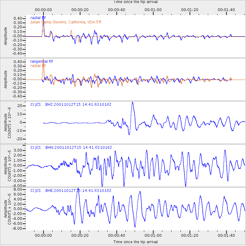
Signal To Noise
| Channel | StoN | STA | LTA |
| CI:JCS: :BHN:20011012T15:14:41.631016Z | 0.38716274 | 1.6093607E-7 | 4.1568066E-7 |
| CI:JCS: :BHE:20011012T15:14:41.631016Z | 1.3247267 | 5.9902914E-7 | 4.521907E-7 |
| CI:JCS: :BHZ:20011012T15:14:41.631016Z | 1.9656597 | 7.218594E-7 | 3.6723517E-7 |
| Arrivals |
| Ps | 4.5 SECOND |
| PpPs | 13 SECOND |
| PsPs/PpSs | 17 SECOND |


