You are here: Home > Network List > TA - USArray Transportable Network (new EarthScope stations) Stations List
> Station 528A Cox Ranch, Sanderson, TX, USA > Earthquake Result Viewer
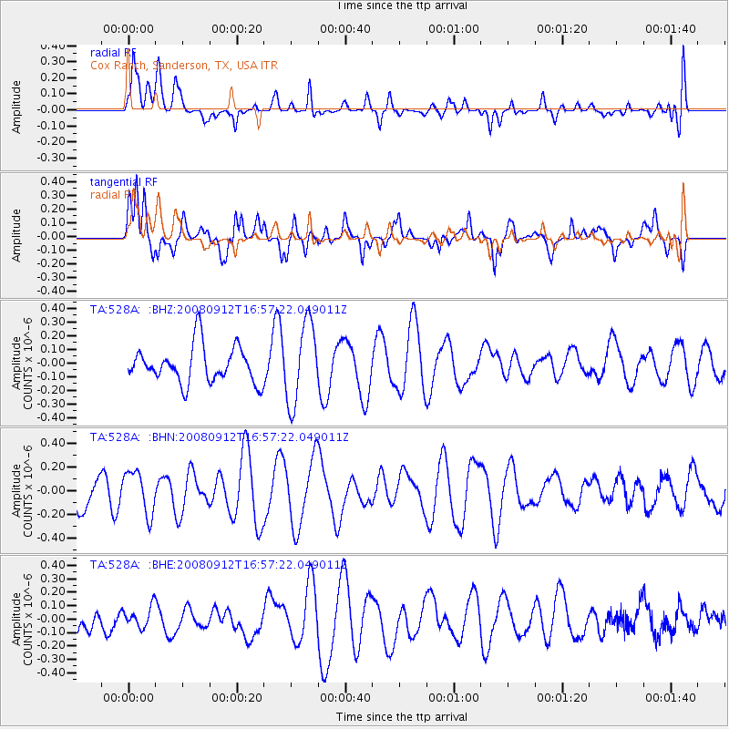
528A Cox Ranch, Sanderson, TX, USA - Earthquake Result Viewer
*The percent match for this event was below the threshold and hence no stack was calculated.
| Earthquake location: |
Southeast Of Loyalty Islands |
| Earthquake latitude/longitude: |
-21.7/170.5 |
| Earthquake time(UTC): |
2008/09/12 (256) 16:44:30 GMT |
| Earthquake Depth: |
116 km |
| Earthquake Magnitude: |
5.8 MW, 5.4 MB, 5.8 MW |
| Earthquake Catalog/Contributor: |
WHDF/NEIC |
|
| Network: |
TA USArray Transportable Network (new EarthScope stations) |
| Station: |
528A Cox Ranch, Sanderson, TX, USA |
| Lat/Lon: |
30.16 N/102.79 W |
| Elevation: |
1183 m |
|
| Distance: |
97.9 deg |
| Az: |
60.81 deg |
| Baz: |
249.643 deg |
| Ray Param: |
$rayparam |
*The percent match for this event was below the threshold and hence was not used in the summary stack. |
|
| Radial Match: |
30.736244 % |
| Radial Bump: |
400 |
| Transverse Match: |
67.284805 % |
| Transverse Bump: |
400 |
| SOD ConfigId: |
2560 |
| Insert Time: |
2010-03-06 10:01:32.105 +0000 |
| GWidth: |
2.5 |
| Max Bumps: |
400 |
| Tol: |
0.001 |
|
Signal To Noise
| Channel | StoN | STA | LTA |
| TA:528A: :BHN:20080912T16:57:22.049011Z | 2.309586 | 1.835814E-7 | 7.948671E-8 |
| TA:528A: :BHE:20080912T16:57:22.049011Z | 0.52848446 | 7.719483E-8 | 1.460683E-7 |
| TA:528A: :BHZ:20080912T16:57:22.049011Z | 2.2436717 | 3.0020627E-7 | 1.3380134E-7 |
| Arrivals |
| Ps | |
| PpPs | |
| PsPs/PpSs | |


