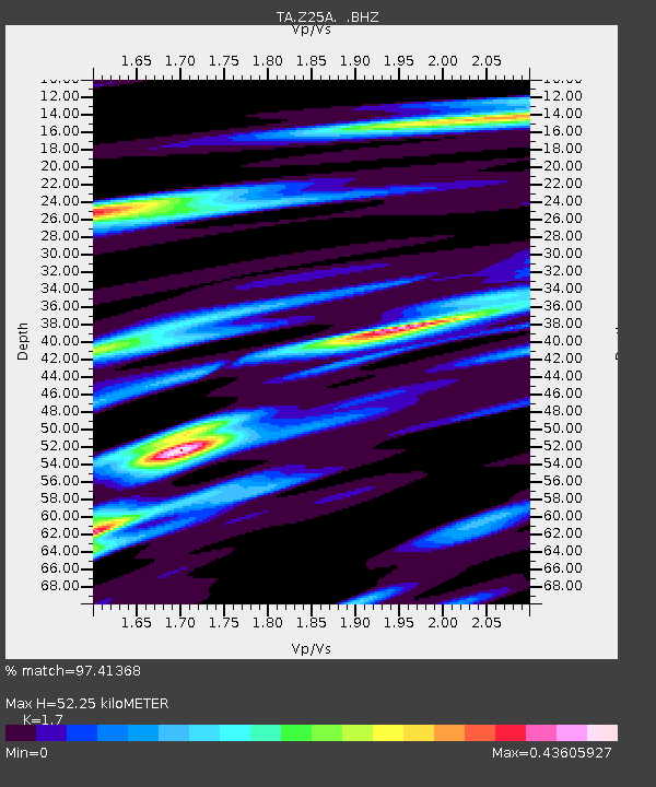
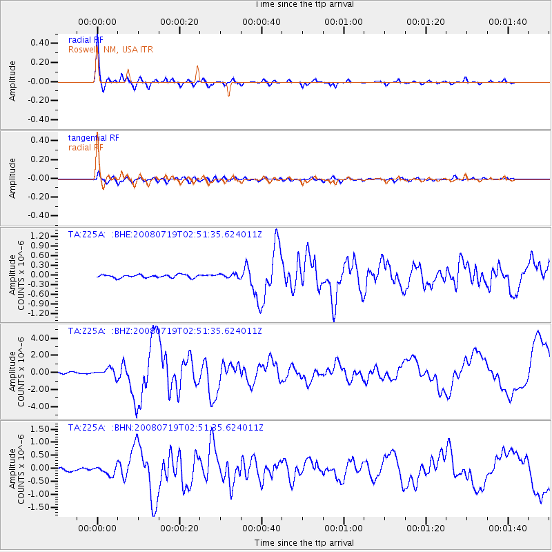
Z25A Roswell, NM, USA - Earthquake Result Viewer

Earthquake location: Off East Coast Of Honshu, Japan
Earthquake latitude/longitude: 37.6/142.2
Earthquake time(UTC): 2008/07/19 (201) 02:39:28 GMT
Earthquake Depth: 22 km
Earthquake Magnitude: 6.2 MB, 7.0 MS, 7.0 MW, 6.9 MW
Earthquake Catalog/Contributor: WHDF/NEIC
Network: TA USArray Transportable Network (new EarthScope stations)
Station: Z25A Roswell, NM, USA
Lat/Lon: 33.28 N/104.72 W
Elevation: 1233 m
Distance: 86.0 deg
Az: 50.59 deg
Baz: 312.858 deg
Ray Param: 0.044375762
Estimated Moho Depth: 52.25 km
Estimated Crust Vp/Vs: 1.70
Assumed Crust Vp: 6.232 km/s
Estimated Crust Vs: 3.666 km/s
Estimated Crust Poisson's Ratio: 0.24
Radial Match: 97.41368 %
Radial Bump: 307
Transverse Match: 79.73351 %
Transverse Bump: 400
SOD ConfigId: 2504
Insert Time: 2010-03-06 10:01:43.750 +0000
GWidth: 2.5
Max Bumps: 400
Tol: 0.001

Signal To Noise

ChannelStoNSTALTA
TA:Z25A: :BHZ:20080719T02:51:35.624011Z4.1487654.8424585E-71.1672048E-7
TA:Z25A: :BHN:20080719T02:51:35.624011Z2.0323681.6956074E-78.343014E-8
TA:Z25A: :BHE:20080719T02:51:35.624011Z1.37087516.171051E-84.501541E-8
Arrivals
Ps6.0 SECOND
PpPs22 SECOND
PsPs/PpSs28 SECOND