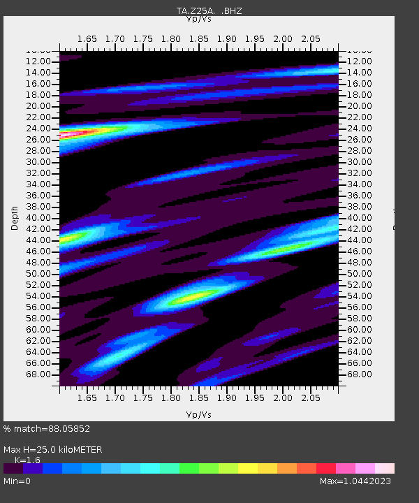
Z25A Roswell, NM, USA - Earthquake Result Viewer
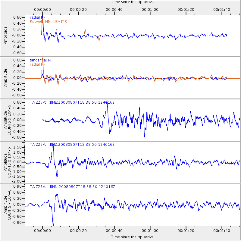
Earthquake location: Andreanof Islands, Aleutian Is.
Earthquake latitude/longitude: 52.2/-175.7
Earthquake time(UTC): 2008/08/07 (220) 18:30:03 GMT
Earthquake Depth: 12 km
Earthquake Magnitude: 5.6 MB, 5.5 MS, 5.8 MW, 5.8 MW
Earthquake Catalog/Contributor: WHDF/NEIC
Network: TA USArray Transportable Network (new EarthScope stations)
Station: Z25A Roswell, NM, USA
Lat/Lon: 33.28 N/104.72 W
Elevation: 1233 m
Distance: 53.2 deg
Az: 81.341 deg
Baz: 313.405 deg
Ray Param: 0.066246174
Estimated Moho Depth: 25.0 km
Estimated Crust Vp/Vs: 1.60
Assumed Crust Vp: 6.232 km/s
Estimated Crust Vs: 3.895 km/s
Estimated Crust Poisson's Ratio: 0.18
Radial Match: 88.05852 %
Radial Bump: 400
Transverse Match: 65.129486 %
Transverse Bump: 400
SOD ConfigId: 2504
Insert Time: 2010-03-06 10:01:52.483 +0000
GWidth: 2.5
Max Bumps: 400
Tol: 0.001

Signal To Noise

ChannelStoNSTALTA
TA:Z25A: :BHZ:20080807T18:38:50.124016Z4.90515662.8070335E-75.7226174E-8
TA:Z25A: :BHN:20080807T18:38:50.124016Z2.60990881.17761054E-74.5120757E-8
TA:Z25A: :BHE:20080807T18:38:50.124016Z3.2205941.2232836E-73.798317E-8
Arrivals
Ps2.5 SECOND
PpPs9.9 SECOND
PsPs/PpSs12 SECOND