You are here: Home > Network List > 2H - Interim Broadband Monitoring of the Mount Erebus Volcano Stations List
> Station NAUS Mt Erebus site NAUS > Earthquake Result Viewer
NAUS Mt Erebus site NAUS - Earthquake Result Viewer
| Earthquake location: |
New Britain Region, P.N.G. |
| Earthquake latitude/longitude: |
-5.5/151.4 |
| Earthquake time(UTC): |
2018/03/26 (085) 09:51:00 GMT |
| Earthquake Depth: |
40 km |
| Earthquake Magnitude: |
6.6 mww |
| Earthquake Catalog/Contributor: |
NEIC PDE/us |
|
| Network: |
2H Interim Broadband Monitoring of the Mount Erebus Volcano |
| Station: |
NAUS Mt Erebus site NAUS |
| Lat/Lon: |
77.52 S/167.15 E |
| Elevation: |
3590 m |
|
| Distance: |
72.5 deg |
| Az: |
176.451 deg |
| Baz: |
343.536 deg |
| Ray Param: |
0.053549897 |
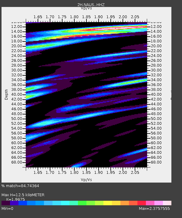
| Estimated Moho Depth: |
12.5 km |
| Estimated Crust Vp/Vs: |
1.97 |
| Assumed Crust Vp: |
6.183 km/s |
| Estimated Crust Vs: |
3.142 km/s |
| Estimated Crust Poisson's Ratio: |
0.33 |
|
| Radial Match: |
84.74364 % |
| Radial Bump: |
400 |
| Transverse Match: |
67.084465 % |
| Transverse Bump: |
400 |
| SOD ConfigId: |
13570011 |
| Insert Time: |
2019-04-30 00:33:12.934 +0000 |
| GWidth: |
2.5 |
| Max Bumps: |
400 |
| Tol: |
0.001 |
|

Signal To Noise
| Channel | StoN | STA | LTA |
| 2H:NAUS: :HHZ:20180326T10:01:52.405017Z | 6.0588737 | 2.1490882E-6 | 3.5470094E-7 |
| 2H:NAUS: :HH1:20180326T10:01:52.405017Z | 2.873986 | 9.271034E-7 | 3.2258453E-7 |
| 2H:NAUS: :HH2:20180326T10:01:52.405017Z | 1.0294931 | 5.0031974E-7 | 4.859865E-7 |
| Arrivals |
| Ps | 2.0 SECOND |
| PpPs | 5.8 SECOND |
| PsPs/PpSs | 7.8 SECOND |


