You are here: Home > Network List > TA - USArray Transportable Network (new EarthScope stations) Stations List
> Station Z25A Roswell, NM, USA > Earthquake Result Viewer
Z25A Roswell, NM, USA - Earthquake Result Viewer
| Earthquake location: |
Tonga Islands |
| Earthquake latitude/longitude: |
-15.1/-173.5 |
| Earthquake time(UTC): |
2008/08/19 (232) 16:30:13 GMT |
| Earthquake Depth: |
8.0 km |
| Earthquake Magnitude: |
5.6 MB, 5.9 MS, 6.1 MW, 6.0 MW |
| Earthquake Catalog/Contributor: |
WHDF/NEIC |
|
| Network: |
TA USArray Transportable Network (new EarthScope stations) |
| Station: |
Z25A Roswell, NM, USA |
| Lat/Lon: |
33.28 N/104.72 W |
| Elevation: |
1233 m |
|
| Distance: |
81.3 deg |
| Az: |
52.18 deg |
| Baz: |
245.632 deg |
| Ray Param: |
0.047712985 |
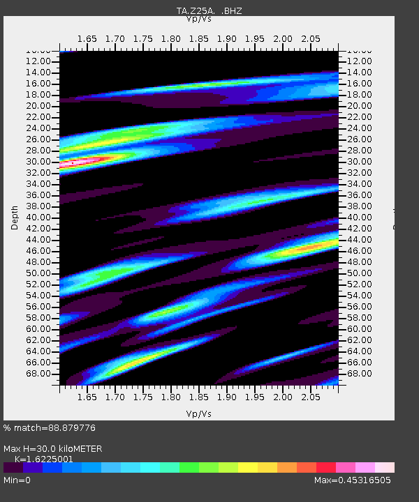
| Estimated Moho Depth: |
30.0 km |
| Estimated Crust Vp/Vs: |
1.62 |
| Assumed Crust Vp: |
6.232 km/s |
| Estimated Crust Vs: |
3.841 km/s |
| Estimated Crust Poisson's Ratio: |
0.19 |
|
| Radial Match: |
88.879776 % |
| Radial Bump: |
399 |
| Transverse Match: |
68.570526 % |
| Transverse Bump: |
400 |
| SOD ConfigId: |
2504 |
| Insert Time: |
2010-03-06 10:01:57.018 +0000 |
| GWidth: |
2.5 |
| Max Bumps: |
400 |
| Tol: |
0.001 |
|
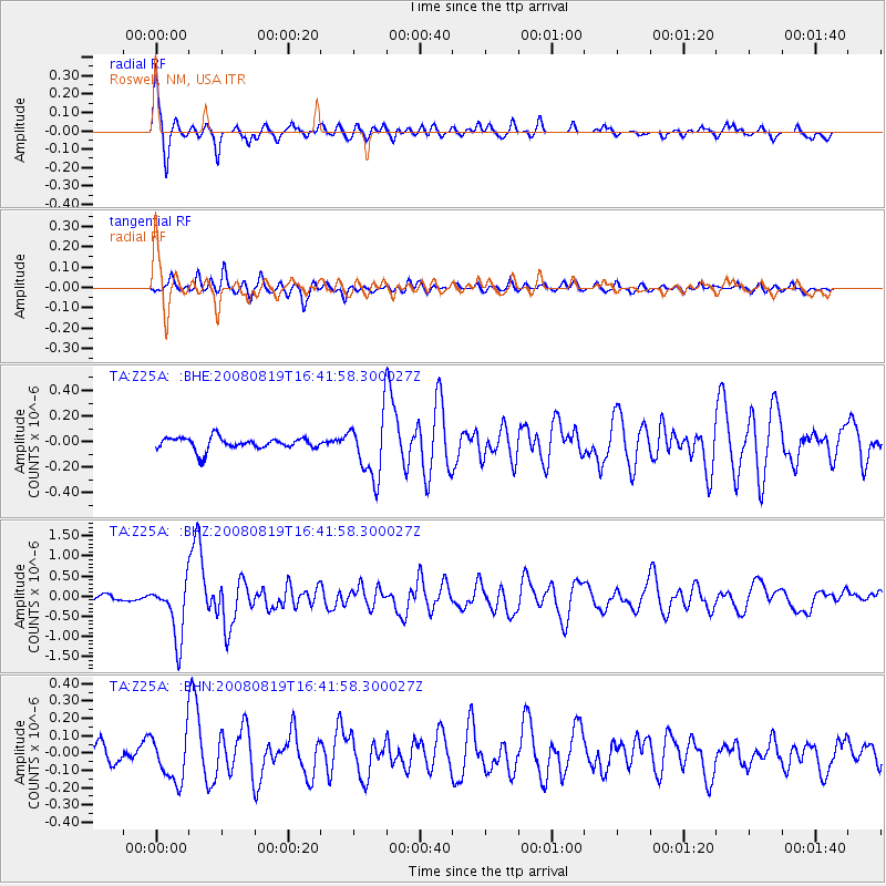
Signal To Noise
| Channel | StoN | STA | LTA |
| TA:Z25A: :BHZ:20080819T16:41:58.300027Z | 12.913769 | 7.050199E-7 | 5.4594434E-8 |
| TA:Z25A: :BHN:20080819T16:41:58.300027Z | 2.2775517 | 1.3323115E-7 | 5.8497534E-8 |
| TA:Z25A: :BHE:20080819T16:41:58.300027Z | 4.9886036 | 2.3866576E-7 | 4.78422E-8 |
| Arrivals |
| Ps | 3.1 SECOND |
| PpPs | 12 SECOND |
| PsPs/PpSs | 15 SECOND |


