You are here: Home > Network List > TA - USArray Transportable Network (new EarthScope stations) Stations List
> Station Z25A Roswell, NM, USA > Earthquake Result Viewer
Z25A Roswell, NM, USA - Earthquake Result Viewer
| Earthquake location: |
Tonga Islands |
| Earthquake latitude/longitude: |
-21.9/-173.8 |
| Earthquake time(UTC): |
2008/10/19 (293) 05:10:33 GMT |
| Earthquake Depth: |
29 km |
| Earthquake Magnitude: |
6.8 MB, 7.0 MS, 6.9 MW, 6.9 MW |
| Earthquake Catalog/Contributor: |
WHDF/NEIC |
|
| Network: |
TA USArray Transportable Network (new EarthScope stations) |
| Station: |
Z25A Roswell, NM, USA |
| Lat/Lon: |
33.28 N/104.72 W |
| Elevation: |
1233 m |
|
| Distance: |
85.7 deg |
| Az: |
51.703 deg |
| Baz: |
240.494 deg |
| Ray Param: |
0.04455744 |
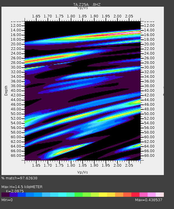
| Estimated Moho Depth: |
14.5 km |
| Estimated Crust Vp/Vs: |
2.10 |
| Assumed Crust Vp: |
6.232 km/s |
| Estimated Crust Vs: |
2.971 km/s |
| Estimated Crust Poisson's Ratio: |
0.35 |
|
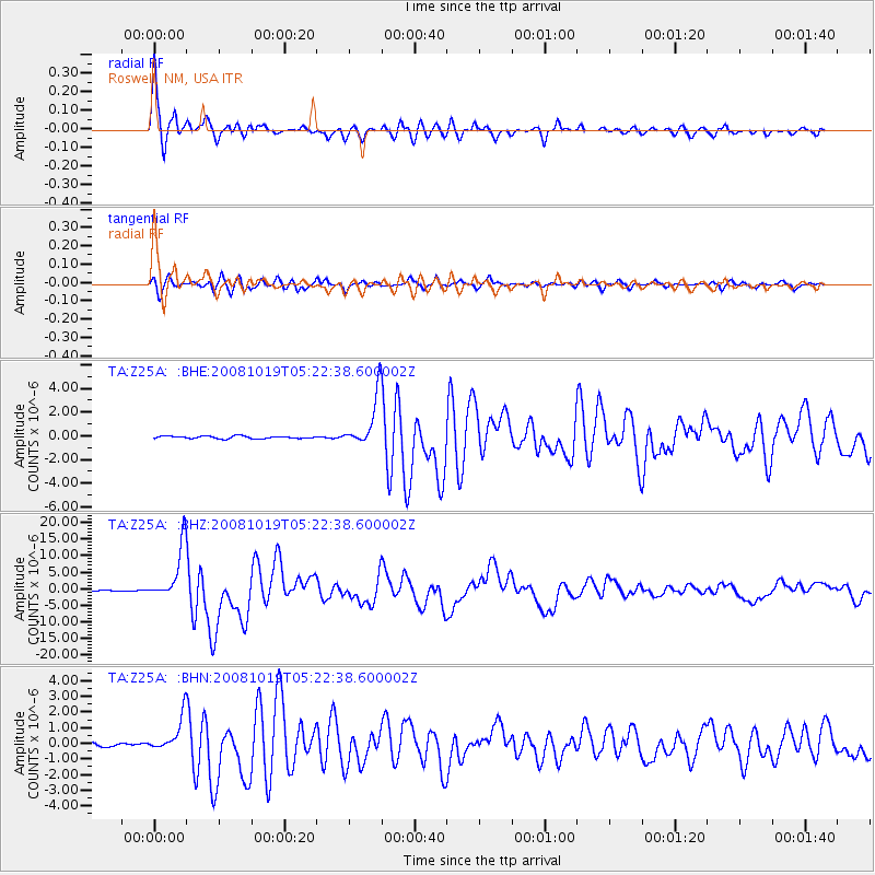
| Radial Match: |
97.62638 % |
| Radial Bump: |
328 |
| Transverse Match: |
93.47979 % |
| Transverse Bump: |
400 |
| SOD ConfigId: |
2556 |
| Insert Time: |
2010-03-06 10:02:04.007 +0000 |
| GWidth: |
2.5 |
| Max Bumps: |
400 |
| Tol: |
0.001 |
|
Signal To Noise
| Channel | StoN | STA | LTA |
| TA:Z25A: :BHZ:20081019T05:22:38.600002Z | 86.38537 | 8.086103E-6 | 9.360501E-8 |
| TA:Z25A: :BHN:20081019T05:22:38.600002Z | 11.253791 | 1.0881729E-6 | 9.66939E-8 |
| TA:Z25A: :BHE:20081019T05:22:38.600002Z | 20.753939 | 2.1809944E-6 | 1.0508822E-7 |
| Arrivals |
| Ps | 2.6 SECOND |
| PpPs | 7.1 SECOND |
| PsPs/PpSs | 9.7 SECOND |


