You are here: Home > Network List > TA - USArray Transportable Network (new EarthScope stations) Stations List
> Station Z25A Roswell, NM, USA > Earthquake Result Viewer
Z25A Roswell, NM, USA - Earthquake Result Viewer
| Earthquake location: |
Colombia |
| Earthquake latitude/longitude: |
4.8/-75.5 |
| Earthquake time(UTC): |
2008/09/13 (257) 09:32:01 GMT |
| Earthquake Depth: |
133 km |
| Earthquake Magnitude: |
5.9 MB, 5.7 MW, 5.7 MW |
| Earthquake Catalog/Contributor: |
WHDF/NEIC |
|
| Network: |
TA USArray Transportable Network (new EarthScope stations) |
| Station: |
Z25A Roswell, NM, USA |
| Lat/Lon: |
33.28 N/104.72 W |
| Elevation: |
1233 m |
|
| Distance: |
39.3 deg |
| Az: |
319.801 deg |
| Baz: |
129.838 deg |
| Ray Param: |
0.07459635 |
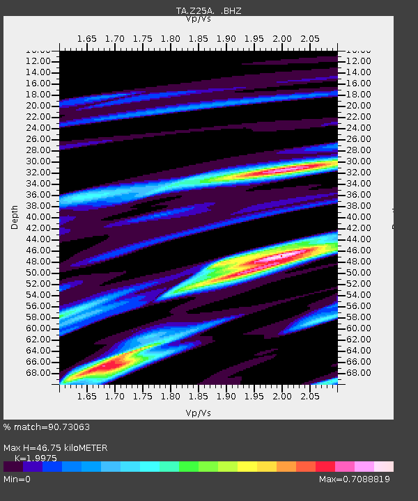
| Estimated Moho Depth: |
46.75 km |
| Estimated Crust Vp/Vs: |
2.00 |
| Assumed Crust Vp: |
6.232 km/s |
| Estimated Crust Vs: |
3.12 km/s |
| Estimated Crust Poisson's Ratio: |
0.33 |
|
| Radial Match: |
90.73063 % |
| Radial Bump: |
357 |
| Transverse Match: |
57.45594 % |
| Transverse Bump: |
393 |
| SOD ConfigId: |
2560 |
| Insert Time: |
2010-03-06 10:02:11.684 +0000 |
| GWidth: |
2.5 |
| Max Bumps: |
400 |
| Tol: |
0.001 |
|
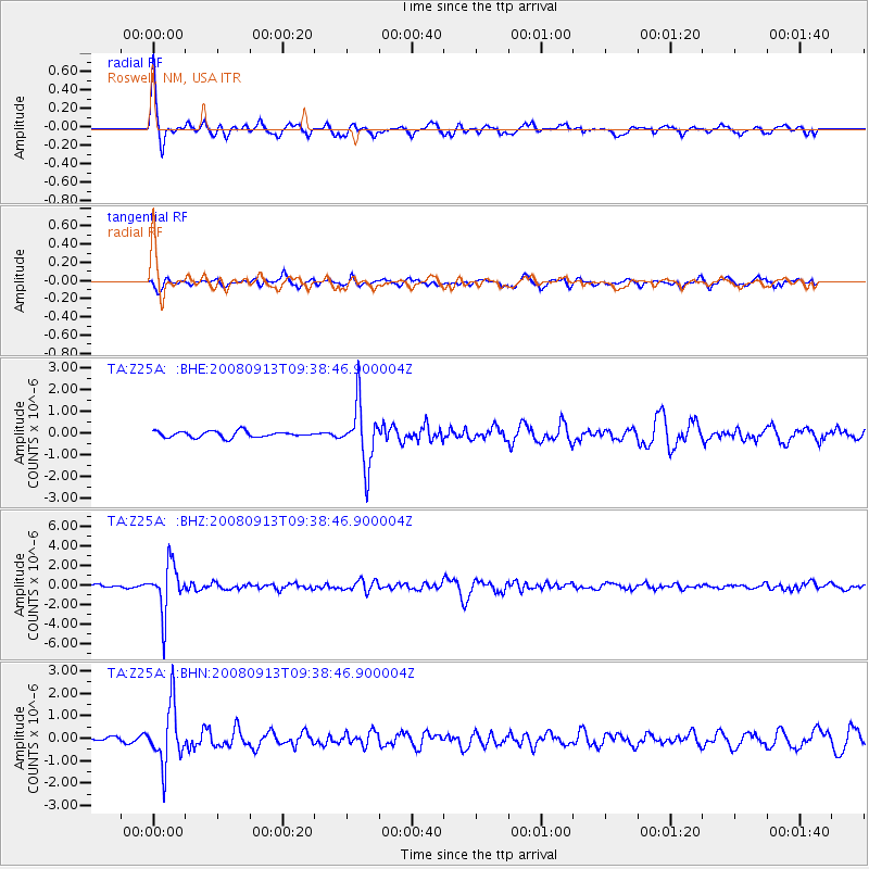
Signal To Noise
| Channel | StoN | STA | LTA |
| TA:Z25A: :BHZ:20080913T09:38:46.900004Z | 8.798757 | 2.4754538E-6 | 2.8134133E-7 |
| TA:Z25A: :BHN:20080913T09:38:46.900004Z | 5.6058664 | 1.2929505E-6 | 2.3064241E-7 |
| TA:Z25A: :BHE:20080913T09:38:46.900004Z | 9.932621 | 1.3782553E-6 | 1.3876048E-7 |
| Arrivals |
| Ps | 7.9 SECOND |
| PpPs | 21 SECOND |
| PsPs/PpSs | 29 SECOND |


