You are here: Home > Network List > TA - USArray Transportable Network (new EarthScope stations) Stations List
> Station Z25A Roswell, NM, USA > Earthquake Result Viewer
Z25A Roswell, NM, USA - Earthquake Result Viewer
| Earthquake location: |
Tonga Islands |
| Earthquake latitude/longitude: |
-20.8/-174.3 |
| Earthquake time(UTC): |
2009/07/30 (211) 20:05:34 GMT |
| Earthquake Depth: |
10 km |
| Earthquake Magnitude: |
5.9 MB, 5.7 MS, 5.8 MW, 5.7 MW |
| Earthquake Catalog/Contributor: |
WHDF/NEIC |
|
| Network: |
TA USArray Transportable Network (new EarthScope stations) |
| Station: |
Z25A Roswell, NM, USA |
| Lat/Lon: |
33.28 N/104.72 W |
| Elevation: |
1233 m |
|
| Distance: |
85.4 deg |
| Az: |
51.942 deg |
| Baz: |
241.541 deg |
| Ray Param: |
0.04481211 |
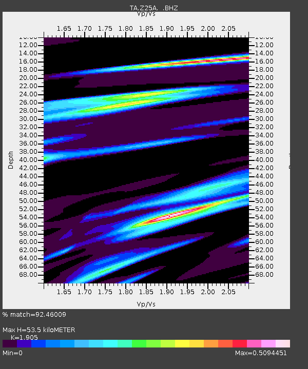
| Estimated Moho Depth: |
53.5 km |
| Estimated Crust Vp/Vs: |
1.90 |
| Assumed Crust Vp: |
6.232 km/s |
| Estimated Crust Vs: |
3.271 km/s |
| Estimated Crust Poisson's Ratio: |
0.31 |
|
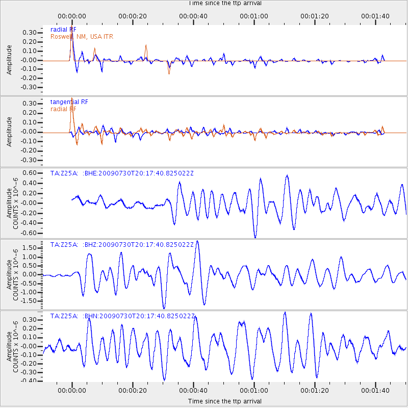
| Radial Match: |
92.46009 % |
| Radial Bump: |
343 |
| Transverse Match: |
83.51713 % |
| Transverse Bump: |
400 |
| SOD ConfigId: |
2622 |
| Insert Time: |
2010-03-06 10:02:23.862 +0000 |
| GWidth: |
2.5 |
| Max Bumps: |
400 |
| Tol: |
0.001 |
|
Signal To Noise
| Channel | StoN | STA | LTA |
| TA:Z25A: :BHZ:20090730T20:17:40.825022Z | 8.249283 | 4.751087E-7 | 5.759394E-8 |
| TA:Z25A: :BHN:20090730T20:17:40.825022Z | 2.3746715 | 9.207227E-8 | 3.8772637E-8 |
| TA:Z25A: :BHE:20090730T20:17:40.825022Z | 2.6890883 | 1.7883629E-7 | 6.650443E-8 |
| Arrivals |
| Ps | 7.9 SECOND |
| PpPs | 24 SECOND |
| PsPs/PpSs | 32 SECOND |


