You are here: Home > Network List > TA - USArray Transportable Network (new EarthScope stations) Stations List
> Station Z25A Roswell, NM, USA > Earthquake Result Viewer
Z25A Roswell, NM, USA - Earthquake Result Viewer
| Earthquake location: |
Southeast Of Honshu, Japan |
| Earthquake latitude/longitude: |
32.8/140.4 |
| Earthquake time(UTC): |
2009/08/12 (224) 22:48:51 GMT |
| Earthquake Depth: |
53 km |
| Earthquake Magnitude: |
6.2 MB, 6.6 MW, 6.6 MW |
| Earthquake Catalog/Contributor: |
WHDF/NEIC |
|
| Network: |
TA USArray Transportable Network (new EarthScope stations) |
| Station: |
Z25A Roswell, NM, USA |
| Lat/Lon: |
33.28 N/104.72 W |
| Elevation: |
1233 m |
|
| Distance: |
90.1 deg |
| Az: |
49.455 deg |
| Baz: |
310.197 deg |
| Ray Param: |
0.041687023 |
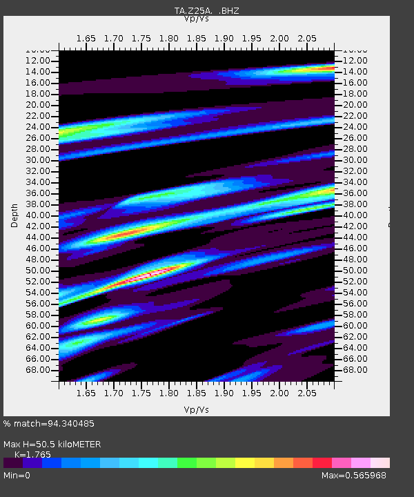
| Estimated Moho Depth: |
50.5 km |
| Estimated Crust Vp/Vs: |
1.76 |
| Assumed Crust Vp: |
6.232 km/s |
| Estimated Crust Vs: |
3.531 km/s |
| Estimated Crust Poisson's Ratio: |
0.26 |
|
| Radial Match: |
94.340485 % |
| Radial Bump: |
290 |
| Transverse Match: |
84.895935 % |
| Transverse Bump: |
400 |
| SOD ConfigId: |
2622 |
| Insert Time: |
2010-03-06 10:02:27.147 +0000 |
| GWidth: |
2.5 |
| Max Bumps: |
400 |
| Tol: |
0.001 |
|
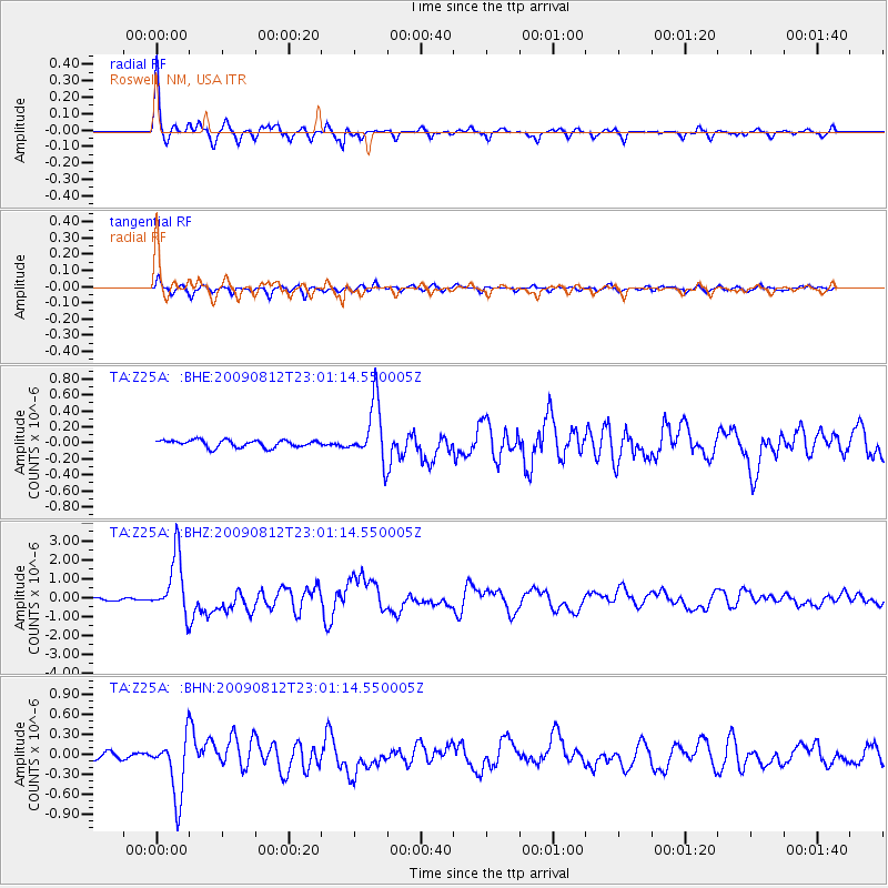
Signal To Noise
| Channel | StoN | STA | LTA |
| TA:Z25A: :BHZ:20090812T23:01:14.550005Z | 32.149017 | 1.5741567E-6 | 4.8964385E-8 |
| TA:Z25A: :BHN:20090812T23:01:14.550005Z | 10.37025 | 4.5696868E-7 | 4.406535E-8 |
| TA:Z25A: :BHE:20090812T23:01:14.550005Z | 8.080778 | 3.6618945E-7 | 4.5316114E-8 |
| Arrivals |
| Ps | 6.3 SECOND |
| PpPs | 22 SECOND |
| PsPs/PpSs | 28 SECOND |


