You are here: Home > Network List > TA - USArray Transportable Network (new EarthScope stations) Stations List
> Station Z25A Roswell, NM, USA > Earthquake Result Viewer
Z25A Roswell, NM, USA - Earthquake Result Viewer
| Earthquake location: |
Azores Islands Region |
| Earthquake latitude/longitude: |
36.2/-33.9 |
| Earthquake time(UTC): |
2009/11/04 (308) 18:41:44 GMT |
| Earthquake Depth: |
10 km |
| Earthquake Magnitude: |
5.7 MB, 5.6 MS, 5.9 MW, 5.8 MW |
| Earthquake Catalog/Contributor: |
WHDF/NEIC |
|
| Network: |
TA USArray Transportable Network (new EarthScope stations) |
| Station: |
Z25A Roswell, NM, USA |
| Lat/Lon: |
33.28 N/104.72 W |
| Elevation: |
1233 m |
|
| Distance: |
57.1 deg |
| Az: |
289.521 deg |
| Baz: |
65.588 deg |
| Ray Param: |
0.06371193 |
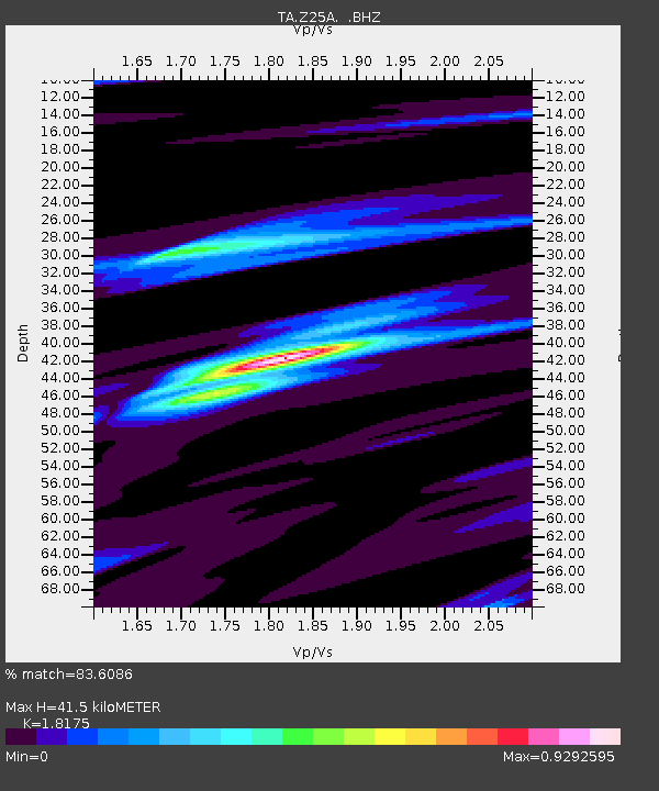
| Estimated Moho Depth: |
41.5 km |
| Estimated Crust Vp/Vs: |
1.82 |
| Assumed Crust Vp: |
6.232 km/s |
| Estimated Crust Vs: |
3.429 km/s |
| Estimated Crust Poisson's Ratio: |
0.28 |
|
| Radial Match: |
83.6086 % |
| Radial Bump: |
292 |
| Transverse Match: |
69.58779 % |
| Transverse Bump: |
376 |
| SOD ConfigId: |
2622 |
| Insert Time: |
2010-03-06 10:02:47.105 +0000 |
| GWidth: |
2.5 |
| Max Bumps: |
400 |
| Tol: |
0.001 |
|
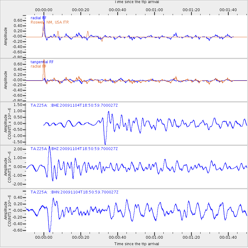
Signal To Noise
| Channel | StoN | STA | LTA |
| TA:Z25A: :BHZ:20091104T18:50:59.700027Z | 7.7848716 | 1.088845E-6 | 1.398668E-7 |
| TA:Z25A: :BHN:20091104T18:50:59.700027Z | 4.459235 | 3.0046664E-7 | 6.738075E-8 |
| TA:Z25A: :BHE:20091104T18:50:59.700027Z | 6.1677146 | 7.2133224E-7 | 1.1695292E-7 |
| Arrivals |
| Ps | 5.7 SECOND |
| PpPs | 18 SECOND |
| PsPs/PpSs | 24 SECOND |


