You are here: Home > Network List > TA - USArray Transportable Network (new EarthScope stations) Stations List
> Station Z25A Roswell, NM, USA > Earthquake Result Viewer
Z25A Roswell, NM, USA - Earthquake Result Viewer
| Earthquake location: |
Sea Of Okhotsk |
| Earthquake latitude/longitude: |
54.2/154.3 |
| Earthquake time(UTC): |
2008/11/24 (329) 09:02:58 GMT |
| Earthquake Depth: |
492 km |
| Earthquake Magnitude: |
6.5 MB, 7.3 MW, 7.3 MW |
| Earthquake Catalog/Contributor: |
WHDF/NEIC |
|
| Network: |
TA USArray Transportable Network (new EarthScope stations) |
| Station: |
Z25A Roswell, NM, USA |
| Lat/Lon: |
33.28 N/104.72 W |
| Elevation: |
1233 m |
|
| Distance: |
69.6 deg |
| Az: |
61.327 deg |
| Baz: |
322.024 deg |
| Ray Param: |
0.053895935 |
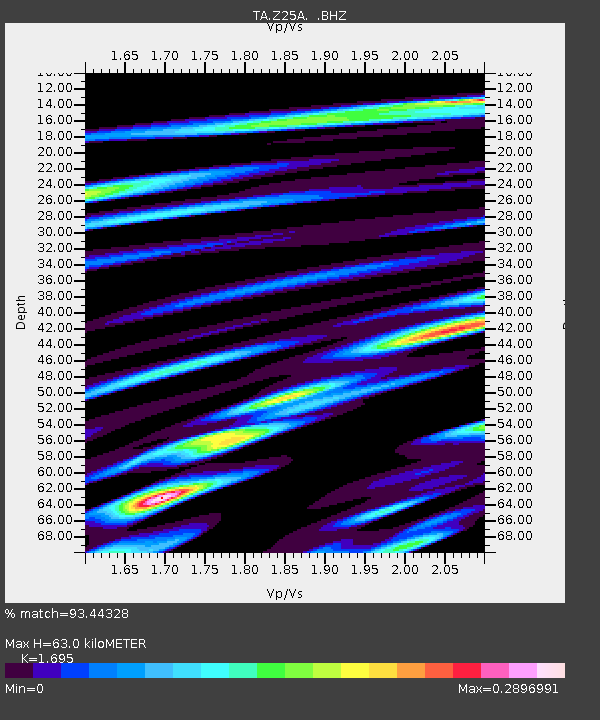
| Estimated Moho Depth: |
63.0 km |
| Estimated Crust Vp/Vs: |
1.70 |
| Assumed Crust Vp: |
6.232 km/s |
| Estimated Crust Vs: |
3.676 km/s |
| Estimated Crust Poisson's Ratio: |
0.23 |
|
| Radial Match: |
93.44328 % |
| Radial Bump: |
208 |
| Transverse Match: |
73.83329 % |
| Transverse Bump: |
380 |
| SOD ConfigId: |
2658 |
| Insert Time: |
2010-03-06 10:02:51.237 +0000 |
| GWidth: |
2.5 |
| Max Bumps: |
400 |
| Tol: |
0.001 |
|
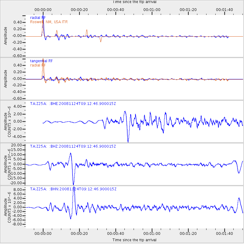
Signal To Noise
| Channel | StoN | STA | LTA |
| TA:Z25A: :BHZ:20081124T09:12:46.900015Z | 7.486689 | 2.195822E-6 | 2.9329678E-7 |
| TA:Z25A: :BHN:20081124T09:12:46.900015Z | 3.8477957 | 9.0422304E-7 | 2.3499767E-7 |
| TA:Z25A: :BHE:20081124T09:12:46.900015Z | 4.007112 | 6.765737E-7 | 1.6884321E-7 |
| Arrivals |
| Ps | 7.3 SECOND |
| PpPs | 26 SECOND |
| PsPs/PpSs | 34 SECOND |


