You are here: Home > Network List > TA - USArray Transportable Network (new EarthScope stations) Stations List
> Station Z25A Roswell, NM, USA > Earthquake Result Viewer
Z25A Roswell, NM, USA - Earthquake Result Viewer
| Earthquake location: |
Northern Mid-Atlantic Ridge |
| Earthquake latitude/longitude: |
47.0/-27.3 |
| Earthquake time(UTC): |
2008/12/19 (354) 08:31:51 GMT |
| Earthquake Depth: |
2.0 km |
| Earthquake Magnitude: |
5.8 MB, 5.6 MS, 5.9 MW, 5.8 MW |
| Earthquake Catalog/Contributor: |
WHDF/NEIC |
|
| Network: |
TA USArray Transportable Network (new EarthScope stations) |
| Station: |
Z25A Roswell, NM, USA |
| Lat/Lon: |
33.28 N/104.72 W |
| Elevation: |
1233 m |
|
| Distance: |
58.5 deg |
| Az: |
286.415 deg |
| Baz: |
51.605 deg |
| Ray Param: |
0.0628436 |
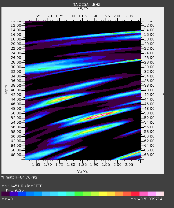
| Estimated Moho Depth: |
51.0 km |
| Estimated Crust Vp/Vs: |
1.91 |
| Assumed Crust Vp: |
6.232 km/s |
| Estimated Crust Vs: |
3.258 km/s |
| Estimated Crust Poisson's Ratio: |
0.31 |
|
| Radial Match: |
84.76792 % |
| Radial Bump: |
290 |
| Transverse Match: |
64.330605 % |
| Transverse Bump: |
348 |
| SOD ConfigId: |
2658 |
| Insert Time: |
2010-03-06 10:03:00.044 +0000 |
| GWidth: |
2.5 |
| Max Bumps: |
400 |
| Tol: |
0.001 |
|
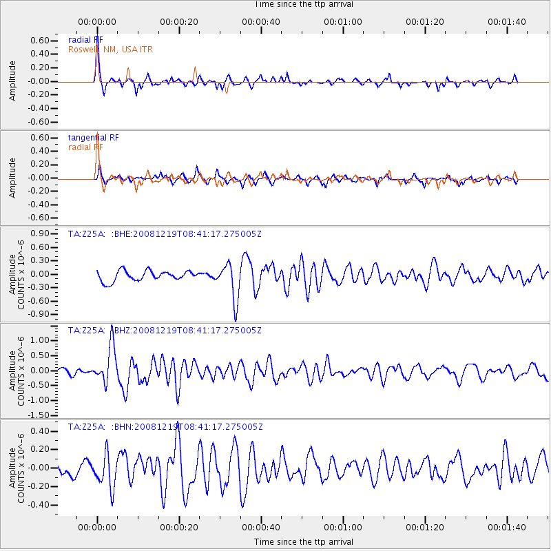
Signal To Noise
| Channel | StoN | STA | LTA |
| TA:Z25A: :BHZ:20081219T08:41:17.275005Z | 6.5966554 | 6.3759694E-7 | 9.6654574E-8 |
| TA:Z25A: :BHN:20081219T08:41:17.275005Z | 1.9888817 | 1.8389348E-7 | 9.246074E-8 |
| TA:Z25A: :BHE:20081219T08:41:17.275005Z | 3.6521707 | 4.1726446E-7 | 1.1425109E-7 |
| Arrivals |
| Ps | 7.8 SECOND |
| PpPs | 23 SECOND |
| PsPs/PpSs | 31 SECOND |


