You are here: Home > Network List > UU - University of Utah Regional Network Stations List
> Station MTPU Mt. Pierson, UT, USA > Earthquake Result Viewer
MTPU Mt. Pierson, UT, USA - Earthquake Result Viewer
| Earthquake location: |
Vanuatu Islands |
| Earthquake latitude/longitude: |
-16.1/167.3 |
| Earthquake time(UTC): |
2016/04/28 (119) 19:33:27 GMT |
| Earthquake Depth: |
35 km |
| Earthquake Magnitude: |
7.0 MO |
| Earthquake Catalog/Contributor: |
NEIC PDE/NEIC ALERT |
|
| Network: |
UU University of Utah Regional Network |
| Station: |
MTPU Mt. Pierson, UT, USA |
| Lat/Lon: |
38.04 N/112.18 W |
| Elevation: |
3112 m |
|
| Distance: |
92.5 deg |
| Az: |
51.208 deg |
| Baz: |
251.615 deg |
| Ray Param: |
0.041435435 |
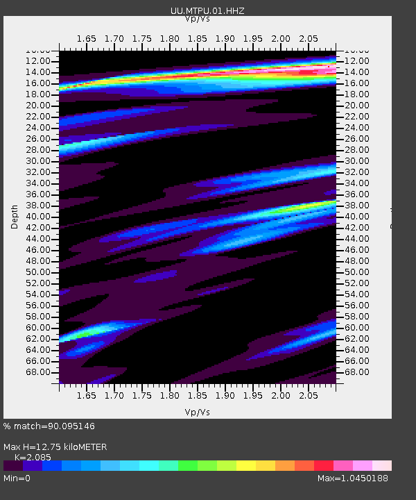
| Estimated Moho Depth: |
12.75 km |
| Estimated Crust Vp/Vs: |
2.09 |
| Assumed Crust Vp: |
6.276 km/s |
| Estimated Crust Vs: |
3.01 km/s |
| Estimated Crust Poisson's Ratio: |
0.35 |
|
| Radial Match: |
90.095146 % |
| Radial Bump: |
248 |
| Transverse Match: |
82.7836 % |
| Transverse Bump: |
400 |
| SOD ConfigId: |
1475611 |
| Insert Time: |
2016-05-12 20:09:09.743 +0000 |
| GWidth: |
2.5 |
| Max Bumps: |
400 |
| Tol: |
0.001 |
|

Signal To Noise
| Channel | StoN | STA | LTA |
| UU:MTPU:01:HHZ:20160428T19:46:03.138Z | 22.015682 | 8.589155E-8 | 3.9013806E-9 |
| UU:MTPU:01:HHN:20160428T19:46:03.138Z | 2.0618029 | 9.383678E-9 | 4.5512003E-9 |
| UU:MTPU:01:HHE:20160428T19:46:03.138Z | 3.3847876 | 1.8900206E-8 | 5.583868E-9 |
| Arrivals |
| Ps | 2.2 SECOND |
| PpPs | 6.2 SECOND |
| PsPs/PpSs | 8.4 SECOND |


