You are here: Home > Network List > TA - USArray Transportable Network (new EarthScope stations) Stations List
> Station Z25A Roswell, NM, USA > Earthquake Result Viewer
Z25A Roswell, NM, USA - Earthquake Result Viewer
| Earthquake location: |
Baffin Bay |
| Earthquake latitude/longitude: |
75.4/-72.5 |
| Earthquake time(UTC): |
2009/07/07 (188) 19:11:46 GMT |
| Earthquake Depth: |
19 km |
| Earthquake Magnitude: |
5.9 MB, 5.7 MS, 6.1 MW, 6.0 MW |
| Earthquake Catalog/Contributor: |
WHDF/NEIC |
|
| Network: |
TA USArray Transportable Network (new EarthScope stations) |
| Station: |
Z25A Roswell, NM, USA |
| Lat/Lon: |
33.28 N/104.72 W |
| Elevation: |
1233 m |
|
| Distance: |
44.9 deg |
| Az: |
219.316 deg |
| Baz: |
11.098 deg |
| Ray Param: |
0.071613945 |
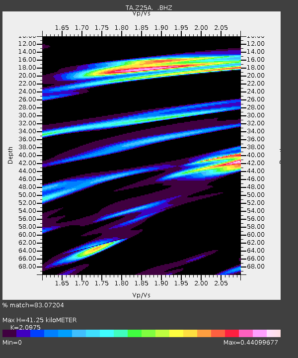
| Estimated Moho Depth: |
41.25 km |
| Estimated Crust Vp/Vs: |
2.10 |
| Assumed Crust Vp: |
6.232 km/s |
| Estimated Crust Vs: |
2.971 km/s |
| Estimated Crust Poisson's Ratio: |
0.35 |
|
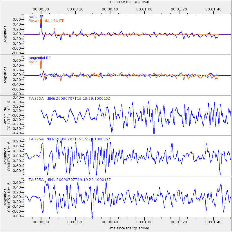
| Radial Match: |
83.07204 % |
| Radial Bump: |
362 |
| Transverse Match: |
67.72394 % |
| Transverse Bump: |
370 |
| SOD ConfigId: |
2648 |
| Insert Time: |
2010-03-06 10:03:09.212 +0000 |
| GWidth: |
2.5 |
| Max Bumps: |
400 |
| Tol: |
0.001 |
|
Signal To Noise
| Channel | StoN | STA | LTA |
| TA:Z25A: :BHZ:20090707T19:19:29.100015Z | 5.774666 | 6.279887E-7 | 1.0874892E-7 |
| TA:Z25A: :BHN:20090707T19:19:29.100015Z | 5.181988 | 4.510378E-7 | 8.703953E-8 |
| TA:Z25A: :BHE:20090707T19:19:29.100015Z | 1.3543406 | 1.141167E-7 | 8.425997E-8 |
| Arrivals |
| Ps | 7.6 SECOND |
| PpPs | 19 SECOND |
| PsPs/PpSs | 27 SECOND |


