You are here: Home > Network List > CN - Canadian National Seismograph Network Stations List
> Station INK INUVIK, NT > Earthquake Result Viewer
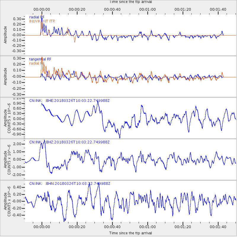
INK INUVIK, NT - Earthquake Result Viewer
*The percent match for this event was below the threshold and hence no stack was calculated.
| Earthquake location: |
New Britain Region, P.N.G. |
| Earthquake latitude/longitude: |
-5.5/151.4 |
| Earthquake time(UTC): |
2018/03/26 (085) 09:51:00 GMT |
| Earthquake Depth: |
40 km |
| Earthquake Magnitude: |
6.6 mww |
| Earthquake Catalog/Contributor: |
NEIC PDE/us |
|
| Network: |
CN Canadian National Seismograph Network |
| Station: |
INK INUVIK, NT |
| Lat/Lon: |
68.31 N/133.53 W |
| Elevation: |
44 m |
|
| Distance: |
89.6 deg |
| Az: |
21.055 deg |
| Baz: |
254.15 deg |
| Ray Param: |
$rayparam |
*The percent match for this event was below the threshold and hence was not used in the summary stack. |
|
| Radial Match: |
64.64165 % |
| Radial Bump: |
400 |
| Transverse Match: |
55.75972 % |
| Transverse Bump: |
400 |
| SOD ConfigId: |
13570011 |
| Insert Time: |
2019-04-30 00:36:23.571 +0000 |
| GWidth: |
2.5 |
| Max Bumps: |
400 |
| Tol: |
0.001 |
|
Signal To Noise
| Channel | StoN | STA | LTA |
| CN:INK: :BHZ:20180326T10:03:22.749988Z | 5.560351 | 1.6176209E-6 | 2.9092067E-7 |
| CN:INK: :BHN:20180326T10:03:22.749988Z | 1.097115 | 1.3814723E-7 | 1.2591863E-7 |
| CN:INK: :BHE:20180326T10:03:22.749988Z | 1.5705373 | 4.6527785E-7 | 2.9625392E-7 |
| Arrivals |
| Ps | |
| PpPs | |
| PsPs/PpSs | |


