You are here: Home > Network List > TA - USArray Transportable Network (new EarthScope stations) Stations List
> Station Z25A Roswell, NM, USA > Earthquake Result Viewer
Z25A Roswell, NM, USA - Earthquake Result Viewer
| Earthquake location: |
Kuril Islands |
| Earthquake latitude/longitude: |
50.8/155.0 |
| Earthquake time(UTC): |
2009/04/21 (111) 05:26:11 GMT |
| Earthquake Depth: |
152 km |
| Earthquake Magnitude: |
6.0 MB, 6.2 MW, 6.2 MW |
| Earthquake Catalog/Contributor: |
WHDF/NEIC |
|
| Network: |
TA USArray Transportable Network (new EarthScope stations) |
| Station: |
Z25A Roswell, NM, USA |
| Lat/Lon: |
33.28 N/104.72 W |
| Elevation: |
1233 m |
|
| Distance: |
70.9 deg |
| Az: |
60.737 deg |
| Baz: |
318.67 deg |
| Ray Param: |
0.05429345 |
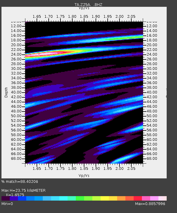
| Estimated Moho Depth: |
23.75 km |
| Estimated Crust Vp/Vs: |
1.66 |
| Assumed Crust Vp: |
6.232 km/s |
| Estimated Crust Vs: |
3.76 km/s |
| Estimated Crust Poisson's Ratio: |
0.21 |
|
| Radial Match: |
88.40206 % |
| Radial Bump: |
351 |
| Transverse Match: |
73.488884 % |
| Transverse Bump: |
400 |
| SOD ConfigId: |
2760 |
| Insert Time: |
2010-03-06 10:03:19.364 +0000 |
| GWidth: |
2.5 |
| Max Bumps: |
400 |
| Tol: |
0.001 |
|
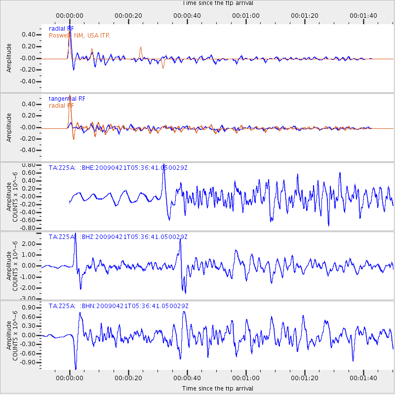
Signal To Noise
| Channel | StoN | STA | LTA |
| TA:Z25A: :BHZ:20090421T05:36:41.050029Z | 10.83467 | 1.1345292E-6 | 1.04712846E-7 |
| TA:Z25A: :BHN:20090421T05:36:41.050029Z | 8.520186 | 4.773257E-7 | 5.6022923E-8 |
| TA:Z25A: :BHE:20090421T05:36:41.050029Z | 3.9051 | 3.516046E-7 | 9.003728E-8 |
| Arrivals |
| Ps | 2.6 SECOND |
| PpPs | 9.8 SECOND |
| PsPs/PpSs | 12 SECOND |


