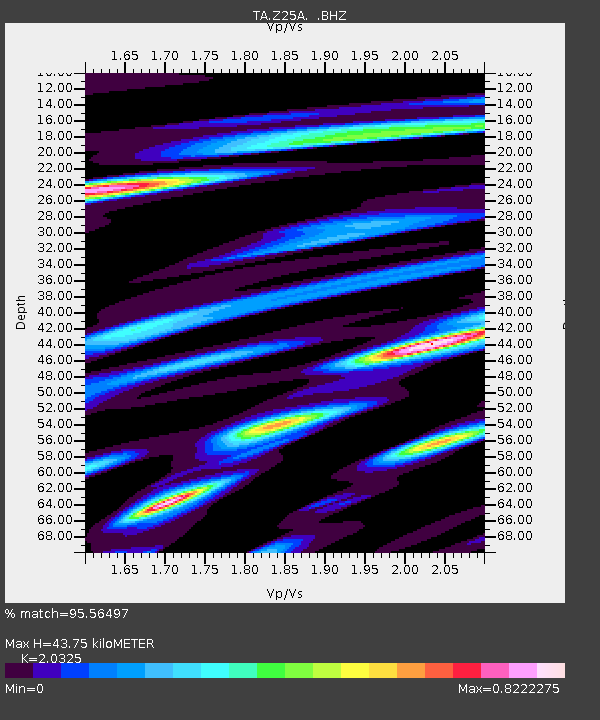
Z25A Roswell, NM, USA - Earthquake Result Viewer
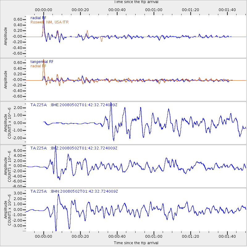
Earthquake location: Andreanof Islands, Aleutian Is.
Earthquake latitude/longitude: 51.9/-177.5
Earthquake time(UTC): 2008/05/02 (123) 01:33:37 GMT
Earthquake Depth: 14 km
Earthquake Magnitude: 6.3 MB, 6.8 MS, 6.6 MW, 6.6 MW
Earthquake Catalog/Contributor: WHDF/NEIC
Network: TA USArray Transportable Network (new EarthScope stations)
Station: Z25A Roswell, NM, USA
Lat/Lon: 33.28 N/104.72 W
Elevation: 1233 m
Distance: 54.4 deg
Az: 79.768 deg
Baz: 313.241 deg
Ray Param: 0.065456145
Estimated Moho Depth: 43.75 km
Estimated Crust Vp/Vs: 2.03
Assumed Crust Vp: 6.232 km/s
Estimated Crust Vs: 3.066 km/s
Estimated Crust Poisson's Ratio: 0.34
Radial Match: 95.56497 %
Radial Bump: 309
Transverse Match: 89.45458 %
Transverse Bump: 400
SOD ConfigId: 2504
Insert Time: 2010-03-06 10:03:24.495 +0000
GWidth: 2.5
Max Bumps: 400
Tol: 0.001

Signal To Noise

ChannelStoNSTALTA
TA:Z25A: :BHZ:20080502T01:42:32.724009Z13.1552471.0696627E-68.131073E-8
TA:Z25A: :BHN:20080502T01:42:32.724009Z4.2943115.55442E-71.2934369E-7
TA:Z25A: :BHE:20080502T01:42:32.724009Z5.0855053.8548916E-77.5801545E-8
Arrivals
Ps7.6 SECOND
PpPs20 SECOND
PsPs/PpSs28 SECOND