You are here: Home > Network List > TA - USArray Transportable Network (new EarthScope stations) Stations List
> Station Z25A Roswell, NM, USA > Earthquake Result Viewer
Z25A Roswell, NM, USA - Earthquake Result Viewer
| Earthquake location: |
Hokkaido, Japan Region |
| Earthquake latitude/longitude: |
41.5/139.0 |
| Earthquake time(UTC): |
2008/06/04 (156) 17:03:07 GMT |
| Earthquake Depth: |
213 km |
| Earthquake Magnitude: |
5.5 MB, 5.7 MW, 5.7 MW |
| Earthquake Catalog/Contributor: |
WHDF/NEIC |
|
| Network: |
TA USArray Transportable Network (new EarthScope stations) |
| Station: |
Z25A Roswell, NM, USA |
| Lat/Lon: |
33.28 N/104.72 W |
| Elevation: |
1233 m |
|
| Distance: |
85.3 deg |
| Az: |
48.937 deg |
| Baz: |
317.488 deg |
| Ray Param: |
0.04439002 |
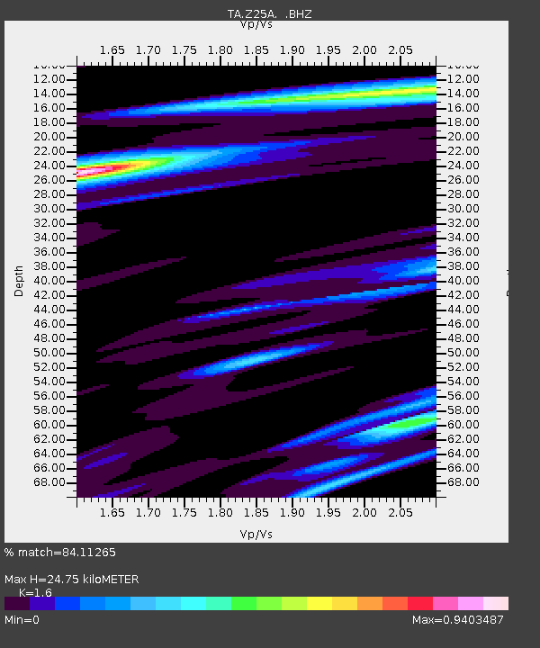
| Estimated Moho Depth: |
24.75 km |
| Estimated Crust Vp/Vs: |
1.60 |
| Assumed Crust Vp: |
6.232 km/s |
| Estimated Crust Vs: |
3.895 km/s |
| Estimated Crust Poisson's Ratio: |
0.18 |
|
| Radial Match: |
84.11265 % |
| Radial Bump: |
387 |
| Transverse Match: |
76.75148 % |
| Transverse Bump: |
400 |
| SOD ConfigId: |
2504 |
| Insert Time: |
2010-03-06 10:03:27.518 +0000 |
| GWidth: |
2.5 |
| Max Bumps: |
400 |
| Tol: |
0.001 |
|
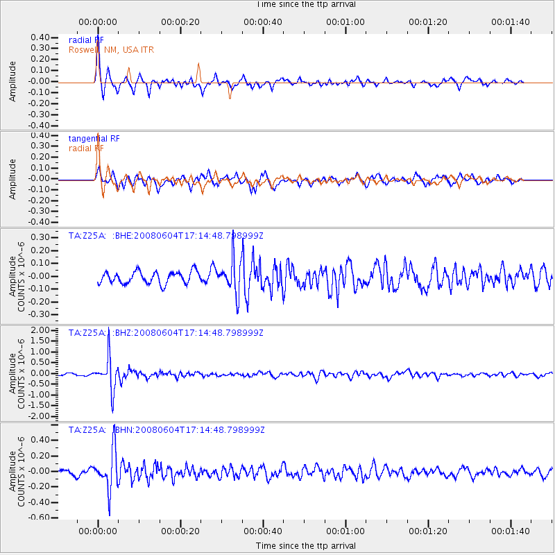
Signal To Noise
| Channel | StoN | STA | LTA |
| TA:Z25A: :BHZ:20080604T17:14:48.798999Z | 17.316914 | 7.575257E-7 | 4.3744844E-8 |
| TA:Z25A: :BHN:20080604T17:14:48.798999Z | 7.118274 | 2.5634867E-7 | 3.6012757E-8 |
| TA:Z25A: :BHE:20080604T17:14:48.798999Z | 2.9026277 | 1.3540236E-7 | 4.66482E-8 |
| Arrivals |
| Ps | 2.4 SECOND |
| PpPs | 10 SECOND |
| PsPs/PpSs | 13 SECOND |


