You are here: Home > Network List > TA - USArray Transportable Network (new EarthScope stations) Stations List
> Station Z25A Roswell, NM, USA > Earthquake Result Viewer
Z25A Roswell, NM, USA - Earthquake Result Viewer
| Earthquake location: |
South Of Panama |
| Earthquake latitude/longitude: |
5.0/-82.7 |
| Earthquake time(UTC): |
2008/06/17 (169) 17:42:09 GMT |
| Earthquake Depth: |
10 km |
| Earthquake Magnitude: |
5.6 MB, 5.3 MS, 5.9 MW, 5.9 MW |
| Earthquake Catalog/Contributor: |
WHDF/NEIC |
|
| Network: |
TA USArray Transportable Network (new EarthScope stations) |
| Station: |
Z25A Roswell, NM, USA |
| Lat/Lon: |
33.28 N/104.72 W |
| Elevation: |
1233 m |
|
| Distance: |
34.8 deg |
| Az: |
326.574 deg |
| Baz: |
139.071 deg |
| Ray Param: |
0.077534705 |
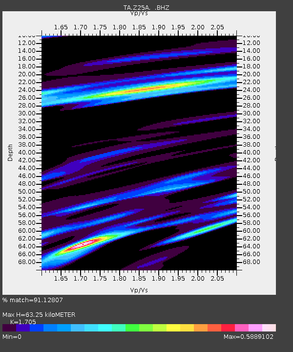
| Estimated Moho Depth: |
63.25 km |
| Estimated Crust Vp/Vs: |
1.71 |
| Assumed Crust Vp: |
6.232 km/s |
| Estimated Crust Vs: |
3.655 km/s |
| Estimated Crust Poisson's Ratio: |
0.24 |
|
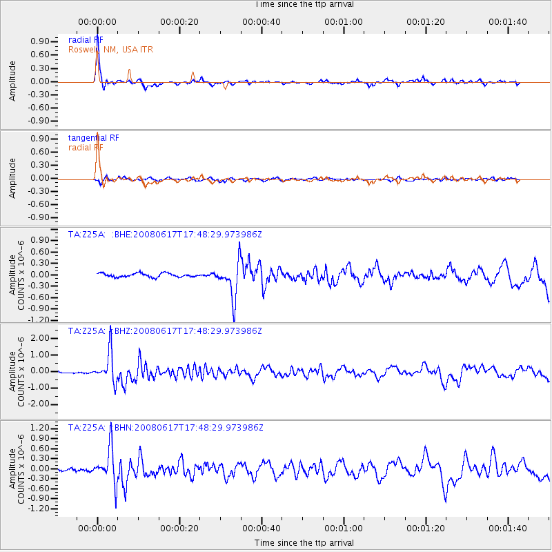
| Radial Match: |
91.12807 % |
| Radial Bump: |
302 |
| Transverse Match: |
66.610344 % |
| Transverse Bump: |
400 |
| SOD ConfigId: |
2504 |
| Insert Time: |
2010-03-06 10:03:30.330 +0000 |
| GWidth: |
2.5 |
| Max Bumps: |
400 |
| Tol: |
0.001 |
|
Signal To Noise
| Channel | StoN | STA | LTA |
| TA:Z25A: :BHZ:20080617T17:48:29.973986Z | 14.496404 | 9.571924E-7 | 6.602965E-8 |
| TA:Z25A: :BHN:20080617T17:48:29.973986Z | 8.694205 | 5.429725E-7 | 6.245222E-8 |
| TA:Z25A: :BHE:20080617T17:48:29.973986Z | 9.781684 | 4.8532223E-7 | 4.9615412E-8 |
| Arrivals |
| Ps | 7.7 SECOND |
| PpPs | 25 SECOND |
| PsPs/PpSs | 33 SECOND |


