You are here: Home > Network List > MM - Myanmar National Seismic Network Stations List
> Station TMU Tamu, Sagaing, Myanmar > Earthquake Result Viewer
TMU Tamu, Sagaing, Myanmar - Earthquake Result Viewer
| Earthquake location: |
New Britain Region, P.N.G. |
| Earthquake latitude/longitude: |
-5.5/151.4 |
| Earthquake time(UTC): |
2018/03/26 (085) 09:51:00 GMT |
| Earthquake Depth: |
40 km |
| Earthquake Magnitude: |
6.6 mww |
| Earthquake Catalog/Contributor: |
NEIC PDE/us |
|
| Network: |
MM Myanmar National Seismic Network |
| Station: |
TMU Tamu, Sagaing, Myanmar |
| Lat/Lon: |
24.23 N/94.30 E |
| Elevation: |
182 m |
|
| Distance: |
62.9 deg |
| Az: |
300.593 deg |
| Baz: |
110.17 deg |
| Ray Param: |
0.059833214 |
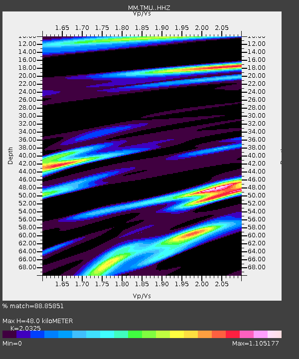
| Estimated Moho Depth: |
48.0 km |
| Estimated Crust Vp/Vs: |
2.03 |
| Assumed Crust Vp: |
6.316 km/s |
| Estimated Crust Vs: |
3.107 km/s |
| Estimated Crust Poisson's Ratio: |
0.34 |
|
| Radial Match: |
88.85851 % |
| Radial Bump: |
400 |
| Transverse Match: |
75.37576 % |
| Transverse Bump: |
400 |
| SOD ConfigId: |
13570011 |
| Insert Time: |
2019-04-30 00:37:43.267 +0000 |
| GWidth: |
2.5 |
| Max Bumps: |
400 |
| Tol: |
0.001 |
|

Signal To Noise
| Channel | StoN | STA | LTA |
| MM:TMU: :HHZ:20180326T10:00:52.238025Z | 15.933117 | 1.9410093E-6 | 1.2182232E-7 |
| MM:TMU: :HHN:20180326T10:00:52.238025Z | 5.9620805 | 5.105349E-7 | 8.5630326E-8 |
| MM:TMU: :HHE:20180326T10:00:52.238025Z | 9.139118 | 8.4486396E-7 | 9.244481E-8 |
| Arrivals |
| Ps | 8.1 SECOND |
| PpPs | 22 SECOND |
| PsPs/PpSs | 30 SECOND |


