You are here: Home > Network List > TA - USArray Transportable Network (new EarthScope stations) Stations List
> Station Z25A Roswell, NM, USA > Earthquake Result Viewer
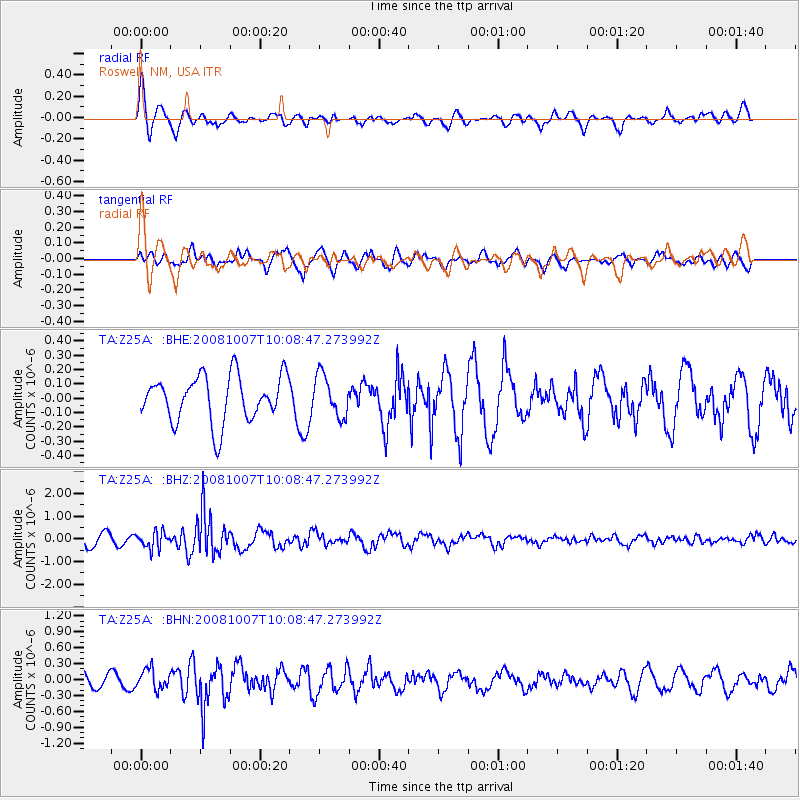
Z25A Roswell, NM, USA - Earthquake Result Viewer
*The percent match for this event was below the threshold and hence no stack was calculated.
| Earthquake location: |
Arctic Ocean |
| Earthquake latitude/longitude: |
79.8/-115.4 |
| Earthquake time(UTC): |
2008/10/07 (281) 10:00:48 GMT |
| Earthquake Depth: |
10 km |
| Earthquake Magnitude: |
5.6 MB, 5.5 MS, 5.7 MW, 5.7 MW |
| Earthquake Catalog/Contributor: |
WHDF/NEIC |
|
| Network: |
TA USArray Transportable Network (new EarthScope stations) |
| Station: |
Z25A Roswell, NM, USA |
| Lat/Lon: |
33.28 N/104.72 W |
| Elevation: |
1233 m |
|
| Distance: |
46.9 deg |
| Az: |
167.656 deg |
| Baz: |
357.397 deg |
| Ray Param: |
$rayparam |
*The percent match for this event was below the threshold and hence was not used in the summary stack. |
|
| Radial Match: |
75.86673 % |
| Radial Bump: |
400 |
| Transverse Match: |
55.236214 % |
| Transverse Bump: |
400 |
| SOD ConfigId: |
2556 |
| Insert Time: |
2010-03-06 10:03:37.632 +0000 |
| GWidth: |
2.5 |
| Max Bumps: |
400 |
| Tol: |
0.001 |
|
Signal To Noise
| Channel | StoN | STA | LTA |
| TA:Z25A: :BHZ:20081007T10:08:47.273992Z | 1.6304665 | 3.6197648E-7 | 2.2200793E-7 |
| TA:Z25A: :BHN:20081007T10:08:47.273992Z | 1.2060943 | 1.8728828E-7 | 1.5528495E-7 |
| TA:Z25A: :BHE:20081007T10:08:47.273992Z | 0.9018765 | 1.442191E-7 | 1.5991003E-7 |
| Arrivals |
| Ps | |
| PpPs | |
| PsPs/PpSs | |


