You are here: Home > Network List > TA - USArray Transportable Network (new EarthScope stations) Stations List
> Station Z25A Roswell, NM, USA > Earthquake Result Viewer
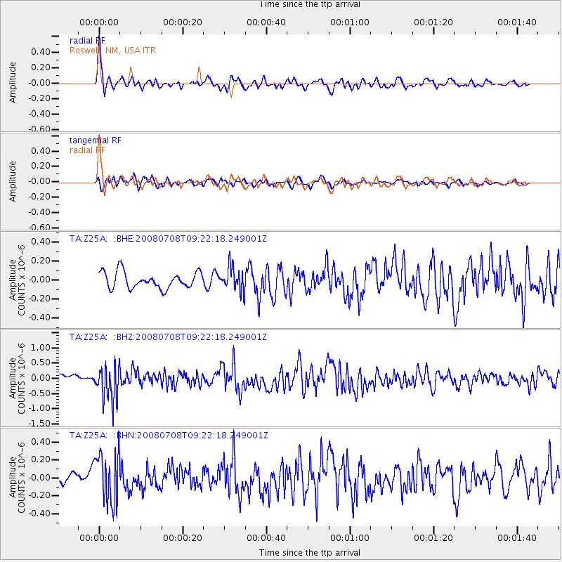
Z25A Roswell, NM, USA - Earthquake Result Viewer
*The percent match for this event was below the threshold and hence no stack was calculated.
| Earthquake location: |
Southern Peru |
| Earthquake latitude/longitude: |
-16.0/-71.7 |
| Earthquake time(UTC): |
2008/07/08 (190) 09:13:07 GMT |
| Earthquake Depth: |
123 km |
| Earthquake Magnitude: |
5.8 MB, 6.2 MW, 6.2 MW |
| Earthquake Catalog/Contributor: |
WHDF/NEIC |
|
| Network: |
TA USArray Transportable Network (new EarthScope stations) |
| Station: |
Z25A Roswell, NM, USA |
| Lat/Lon: |
33.28 N/104.72 W |
| Elevation: |
1233 m |
|
| Distance: |
58.2 deg |
| Az: |
327.576 deg |
| Baz: |
142.002 deg |
| Ray Param: |
$rayparam |
*The percent match for this event was below the threshold and hence was not used in the summary stack. |
|
| Radial Match: |
72.33338 % |
| Radial Bump: |
400 |
| Transverse Match: |
43.679897 % |
| Transverse Bump: |
400 |
| SOD ConfigId: |
2504 |
| Insert Time: |
2010-03-06 10:03:59.599 +0000 |
| GWidth: |
2.5 |
| Max Bumps: |
400 |
| Tol: |
0.001 |
|
Signal To Noise
| Channel | StoN | STA | LTA |
| TA:Z25A: :BHZ:20080708T09:22:18.249001Z | 6.229957 | 5.7853305E-7 | 9.286308E-8 |
| TA:Z25A: :BHN:20080708T09:22:18.249001Z | 4.7677426 | 2.7630477E-7 | 5.7952953E-8 |
| TA:Z25A: :BHE:20080708T09:22:18.249001Z | 1.4727838 | 1.2566308E-7 | 8.53235E-8 |
| Arrivals |
| Ps | |
| PpPs | |
| PsPs/PpSs | |


