You are here: Home > Network List > TA - USArray Transportable Network (new EarthScope stations) Stations List
> Station A22K Sinclair Lake, AK, USA > Earthquake Result Viewer
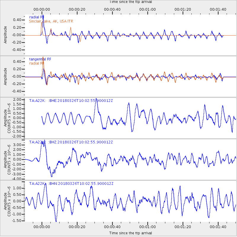
A22K Sinclair Lake, AK, USA - Earthquake Result Viewer
| Earthquake location: |
New Britain Region, P.N.G. |
| Earthquake latitude/longitude: |
-5.5/151.4 |
| Earthquake time(UTC): |
2018/03/26 (085) 09:51:00 GMT |
| Earthquake Depth: |
40 km |
| Earthquake Magnitude: |
6.6 mww |
| Earthquake Catalog/Contributor: |
NEIC PDE/us |
|
| Network: |
TA USArray Transportable Network (new EarthScope stations) |
| Station: |
A22K Sinclair Lake, AK, USA |
| Lat/Lon: |
71.00 N/154.97 W |
| Elevation: |
6.0 m |
|
| Distance: |
84.0 deg |
| Az: |
15.374 deg |
| Baz: |
233.704 deg |
| Ray Param: |
0.04570812 |
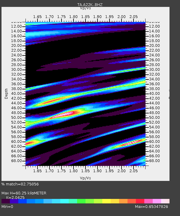
| Estimated Moho Depth: |
60.25 km |
| Estimated Crust Vp/Vs: |
2.04 |
| Assumed Crust Vp: |
5.782 km/s |
| Estimated Crust Vs: |
2.831 km/s |
| Estimated Crust Poisson's Ratio: |
0.34 |
|
| Radial Match: |
82.75856 % |
| Radial Bump: |
333 |
| Transverse Match: |
56.982292 % |
| Transverse Bump: |
400 |
| SOD ConfigId: |
13570011 |
| Insert Time: |
2019-04-30 00:39:05.774 +0000 |
| GWidth: |
2.5 |
| Max Bumps: |
400 |
| Tol: |
0.001 |
|
Signal To Noise
| Channel | StoN | STA | LTA |
| TA:A22K: :BHZ:20180326T10:02:55.900012Z | 13.838557 | 2.5548798E-6 | 1.8462038E-7 |
| TA:A22K: :BHN:20180326T10:02:55.900012Z | 3.810416 | 6.7418864E-7 | 1.7693309E-7 |
| TA:A22K: :BHE:20180326T10:02:55.900012Z | 2.7929463 | 1.109474E-6 | 3.9724148E-7 |
| Arrivals |
| Ps | 11 SECOND |
| PpPs | 31 SECOND |
| PsPs/PpSs | 42 SECOND |


