You are here: Home > Network List > WY - Yellowstone Wyoming Seismic Network Stations List
> Station YHH Holmes Hill, YNP, WY, USA > Earthquake Result Viewer
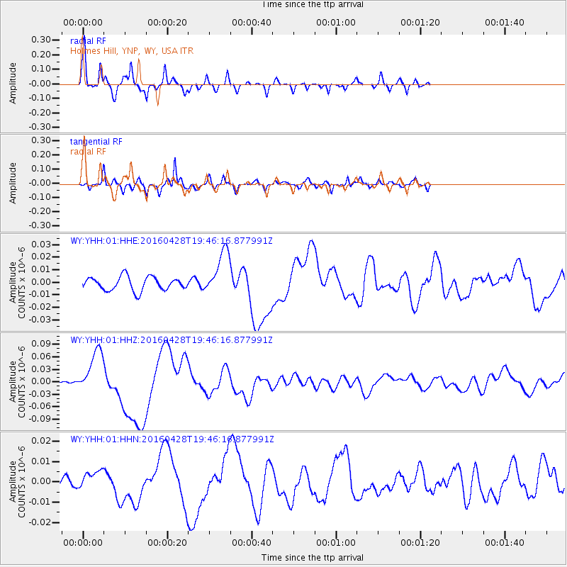
YHH Holmes Hill, YNP, WY, USA - Earthquake Result Viewer
| Earthquake location: |
Vanuatu Islands |
| Earthquake latitude/longitude: |
-16.1/167.3 |
| Earthquake time(UTC): |
2016/04/28 (119) 19:33:27 GMT |
| Earthquake Depth: |
35 km |
| Earthquake Magnitude: |
7.0 MO |
| Earthquake Catalog/Contributor: |
NEIC PDE/NEIC ALERT |
|
| Network: |
WY Yellowstone Wyoming Seismic Network |
| Station: |
YHH Holmes Hill, YNP, WY, USA |
| Lat/Lon: |
44.79 N/110.85 W |
| Elevation: |
2717 m |
|
| Distance: |
95.5 deg |
| Az: |
45.079 deg |
| Baz: |
252.923 deg |
| Ray Param: |
0.040748548 |
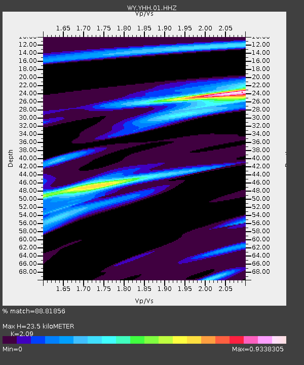
| Estimated Moho Depth: |
23.5 km |
| Estimated Crust Vp/Vs: |
2.09 |
| Assumed Crust Vp: |
6.35 km/s |
| Estimated Crust Vs: |
3.038 km/s |
| Estimated Crust Poisson's Ratio: |
0.35 |
|
| Radial Match: |
88.81856 % |
| Radial Bump: |
265 |
| Transverse Match: |
89.55844 % |
| Transverse Bump: |
398 |
| SOD ConfigId: |
1475611 |
| Insert Time: |
2016-05-12 20:11:27.933 +0000 |
| GWidth: |
2.5 |
| Max Bumps: |
400 |
| Tol: |
0.001 |
|
Signal To Noise
| Channel | StoN | STA | LTA |
| WY:YHH:01:HHZ:20160428T19:46:16.877991Z | 18.212017 | 5.5575075E-8 | 3.0515606E-9 |
| WY:YHH:01:HHN:20160428T19:46:16.877991Z | 1.6018355 | 4.7791575E-9 | 2.983551E-9 |
| WY:YHH:01:HHE:20160428T19:46:16.877991Z | 3.4239955 | 1.8442432E-8 | 5.3862315E-9 |
| Arrivals |
| Ps | 4.1 SECOND |
| PpPs | 11 SECOND |
| PsPs/PpSs | 15 SECOND |


