You are here: Home > Network List > TA - USArray Transportable Network (new EarthScope stations) Stations List
> Station D23K Nanushuk River, AK USA > Earthquake Result Viewer
D23K Nanushuk River, AK USA - Earthquake Result Viewer
| Earthquake location: |
New Britain Region, P.N.G. |
| Earthquake latitude/longitude: |
-5.5/151.4 |
| Earthquake time(UTC): |
2018/03/26 (085) 09:51:00 GMT |
| Earthquake Depth: |
40 km |
| Earthquake Magnitude: |
6.6 mww |
| Earthquake Catalog/Contributor: |
NEIC PDE/us |
|
| Network: |
TA USArray Transportable Network (new EarthScope stations) |
| Station: |
D23K Nanushuk River, AK USA |
| Lat/Lon: |
68.97 N/150.68 W |
| Elevation: |
406 m |
|
| Distance: |
84.1 deg |
| Az: |
17.911 deg |
| Baz: |
237.998 deg |
| Ray Param: |
0.04565743 |
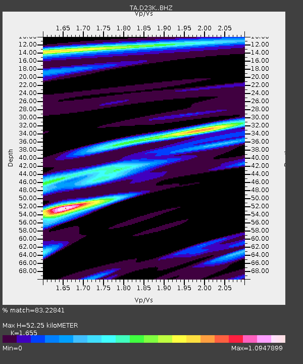
| Estimated Moho Depth: |
52.25 km |
| Estimated Crust Vp/Vs: |
1.65 |
| Assumed Crust Vp: |
6.221 km/s |
| Estimated Crust Vs: |
3.759 km/s |
| Estimated Crust Poisson's Ratio: |
0.21 |
|
| Radial Match: |
83.22841 % |
| Radial Bump: |
390 |
| Transverse Match: |
65.3895 % |
| Transverse Bump: |
400 |
| SOD ConfigId: |
13570011 |
| Insert Time: |
2019-04-30 00:39:21.544 +0000 |
| GWidth: |
2.5 |
| Max Bumps: |
400 |
| Tol: |
0.001 |
|
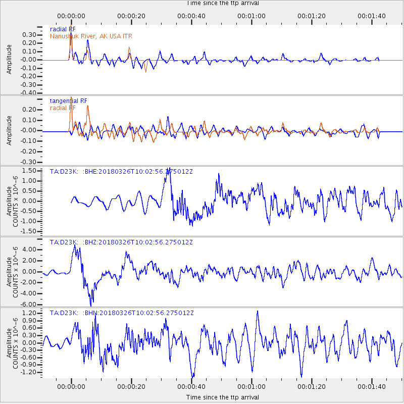
Signal To Noise
| Channel | StoN | STA | LTA |
| TA:D23K: :BHZ:20180326T10:02:56.275012Z | 14.220711 | 2.9213331E-6 | 2.0542807E-7 |
| TA:D23K: :BHN:20180326T10:02:56.275012Z | 2.2166698 | 4.915067E-7 | 2.2173202E-7 |
| TA:D23K: :BHE:20180326T10:02:56.275012Z | 3.9104557 | 9.1373835E-7 | 2.3366543E-7 |
| Arrivals |
| Ps | 5.6 SECOND |
| PpPs | 22 SECOND |
| PsPs/PpSs | 27 SECOND |


