You are here: Home > Network List > WY - Yellowstone Wyoming Seismic Network Stations List
> Station YPP Pitchstone Plateau, YNP, WY, USA > Earthquake Result Viewer
YPP Pitchstone Plateau, YNP, WY, USA - Earthquake Result Viewer
| Earthquake location: |
Vanuatu Islands |
| Earthquake latitude/longitude: |
-16.1/167.3 |
| Earthquake time(UTC): |
2016/04/28 (119) 19:33:27 GMT |
| Earthquake Depth: |
35 km |
| Earthquake Magnitude: |
7.0 MO |
| Earthquake Catalog/Contributor: |
NEIC PDE/NEIC ALERT |
|
| Network: |
WY Yellowstone Wyoming Seismic Network |
| Station: |
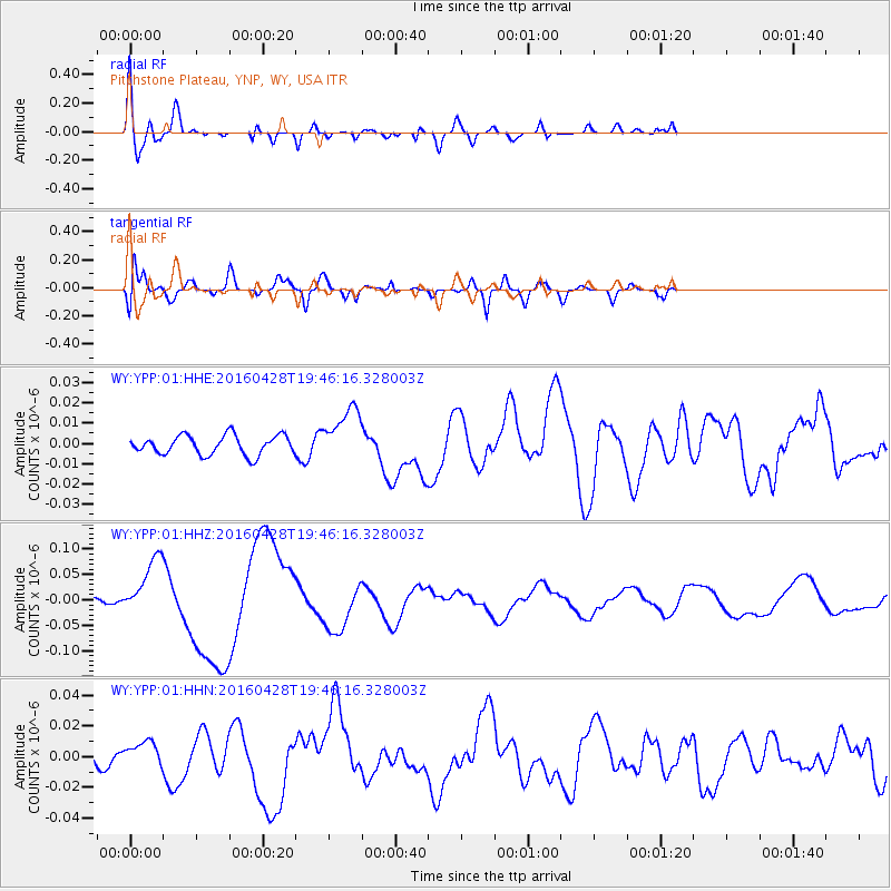
YPP Pitchstone Plateau, YNP, WY, USA |
| Lat/Lon: |
44.27 N/110.80 W |
| Elevation: |
2707 m |
|
| Distance: |
95.4 deg |
| Az: |
45.586 deg |
| Baz: |
252.908 deg |
| Ray Param: |
0.040780537 |
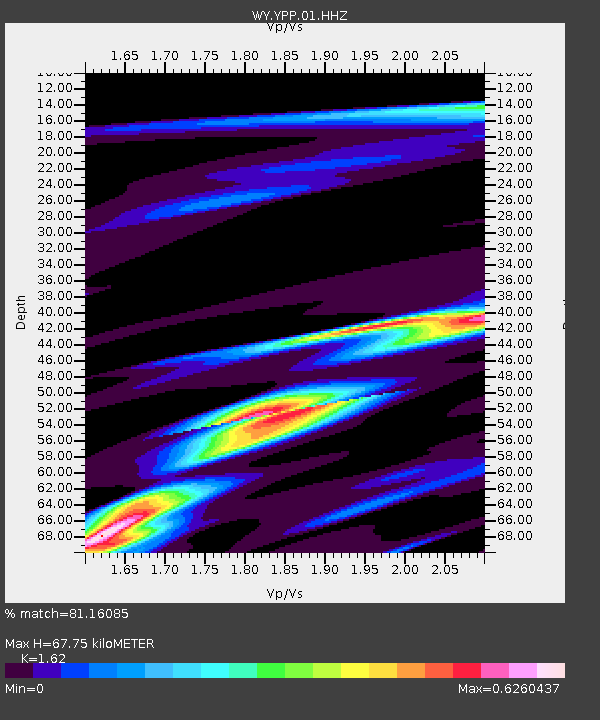
| Estimated Moho Depth: |
67.75 km |
| Estimated Crust Vp/Vs: |
1.62 |
| Assumed Crust Vp: |
6.35 km/s |
| Estimated Crust Vs: |
3.92 km/s |
| Estimated Crust Poisson's Ratio: |
0.19 |
|
| Radial Match: |
81.16085 % |
| Radial Bump: |
400 |
| Transverse Match: |
84.02206 % |
| Transverse Bump: |
400 |
| SOD ConfigId: |
1475611 |
| Insert Time: |
2016-05-12 20:12:07.443 +0000 |
| GWidth: |
2.5 |
| Max Bumps: |
400 |
| Tol: |
0.001 |
|
Signal To Noise
| Channel | StoN | STA | LTA |
| WY:YPP:01:HHZ:20160428T19:46:16.328003Z | 17.449907 | 5.810833E-8 | 3.3300078E-9 |
| WY:YPP:01:HHN:20160428T19:46:16.328003Z | 1.4673432 | 8.134397E-9 | 5.543623E-9 |
| WY:YPP:01:HHE:20160428T19:46:16.328003Z | 2.8488338 | 1.3504162E-8 | 4.7402424E-9 |
| Arrivals |
| Ps | 6.8 SECOND |
| PpPs | 27 SECOND |
| PsPs/PpSs | 34 SECOND |


