You are here: Home > Network List > TA - USArray Transportable Network (new EarthScope stations) Stations List
> Station J29N Klondike Camp, Yukon, CA > Earthquake Result Viewer
J29N Klondike Camp, Yukon, CA - Earthquake Result Viewer
| Earthquake location: |
New Britain Region, P.N.G. |
| Earthquake latitude/longitude: |
-5.5/151.4 |
| Earthquake time(UTC): |
2018/03/26 (085) 09:51:00 GMT |
| Earthquake Depth: |
40 km |
| Earthquake Magnitude: |
6.6 mww |
| Earthquake Catalog/Contributor: |
NEIC PDE/us |
|
| Network: |
TA USArray Transportable Network (new EarthScope stations) |
| Station: |
J29N Klondike Camp, Yukon, CA |
| Lat/Lon: |
64.45 N/138.22 W |
| Elevation: |
982 m |
|
| Distance: |
86.6 deg |
| Az: |
24.154 deg |
| Baz: |
249.958 deg |
| Ray Param: |
0.04389127 |
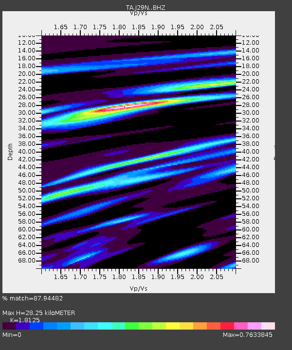
| Estimated Moho Depth: |
28.25 km |
| Estimated Crust Vp/Vs: |
1.81 |
| Assumed Crust Vp: |
6.566 km/s |
| Estimated Crust Vs: |
3.623 km/s |
| Estimated Crust Poisson's Ratio: |
0.28 |
|
| Radial Match: |
87.94482 % |
| Radial Bump: |
400 |
| Transverse Match: |
48.05327 % |
| Transverse Bump: |
400 |
| SOD ConfigId: |
13570011 |
| Insert Time: |
2019-04-30 00:40:17.272 +0000 |
| GWidth: |
2.5 |
| Max Bumps: |
400 |
| Tol: |
0.001 |
|

Signal To Noise
| Channel | StoN | STA | LTA |
| TA:J29N: :BHZ:20180326T10:03:08.549976Z | 12.827592 | 2.534818E-6 | 1.976067E-7 |
| TA:J29N: :BHN:20180326T10:03:08.549976Z | 1.1658472 | 4.152286E-7 | 3.561604E-7 |
| TA:J29N: :BHE:20180326T10:03:08.549976Z | 3.3952212 | 9.4027905E-7 | 2.769419E-7 |
| Arrivals |
| Ps | 3.6 SECOND |
| PpPs | 12 SECOND |
| PsPs/PpSs | 15 SECOND |


