You are here: Home > Network List > TA - USArray Transportable Network (new EarthScope stations) Stations List
> Station K29M Barlow Dome, YT, CAN > Earthquake Result Viewer
K29M Barlow Dome, YT, CAN - Earthquake Result Viewer
| Earthquake location: |
New Britain Region, P.N.G. |
| Earthquake latitude/longitude: |
-5.5/151.4 |
| Earthquake time(UTC): |
2018/03/26 (085) 09:51:00 GMT |
| Earthquake Depth: |
40 km |
| Earthquake Magnitude: |
6.6 mww |
| Earthquake Catalog/Contributor: |
NEIC PDE/us |
|
| Network: |
TA USArray Transportable Network (new EarthScope stations) |
| Station: |
K29M Barlow Dome, YT, CAN |
| Lat/Lon: |
63.84 N/137.52 W |
| Elevation: |
1367 m |
|
| Distance: |
86.7 deg |
| Az: |
24.834 deg |
| Baz: |
250.624 deg |
| Ray Param: |
0.043831926 |
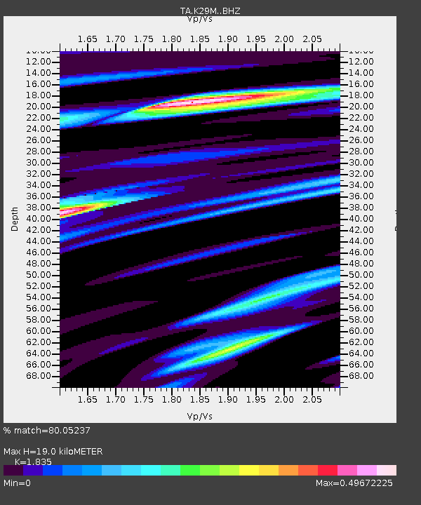
| Estimated Moho Depth: |
19.0 km |
| Estimated Crust Vp/Vs: |
1.84 |
| Assumed Crust Vp: |
6.566 km/s |
| Estimated Crust Vs: |
3.578 km/s |
| Estimated Crust Poisson's Ratio: |
0.29 |
|
| Radial Match: |
80.05237 % |
| Radial Bump: |
400 |
| Transverse Match: |
68.24239 % |
| Transverse Bump: |
400 |
| SOD ConfigId: |
13570011 |
| Insert Time: |
2019-04-30 00:40:23.538 +0000 |
| GWidth: |
2.5 |
| Max Bumps: |
400 |
| Tol: |
0.001 |
|

Signal To Noise
| Channel | StoN | STA | LTA |
| TA:K29M: :BHZ:20180326T10:03:08.950Z | 13.814629 | 2.5087982E-6 | 1.8160445E-7 |
| TA:K29M: :BHN:20180326T10:03:08.950Z | 1.8282925 | 3.5510658E-7 | 1.9422853E-7 |
| TA:K29M: :BHE:20180326T10:03:08.950Z | 2.9060655 | 7.6130897E-7 | 2.6197242E-7 |
| Arrivals |
| Ps | 2.5 SECOND |
| PpPs | 8.0 SECOND |
| PsPs/PpSs | 10 SECOND |


