You are here: Home > Network List > TA - USArray Transportable Network (new EarthScope stations) Stations List
> Station O17K Koliganek, Bristol Bay, AK, USA > Earthquake Result Viewer
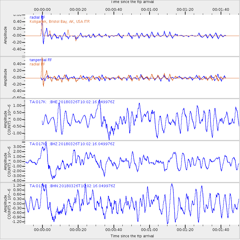
O17K Koliganek, Bristol Bay, AK, USA - Earthquake Result Viewer
*The percent match for this event was below the threshold and hence no stack was calculated.
| Earthquake location: |
New Britain Region, P.N.G. |
| Earthquake latitude/longitude: |
-5.5/151.4 |
| Earthquake time(UTC): |
2018/03/26 (085) 09:51:00 GMT |
| Earthquake Depth: |
40 km |
| Earthquake Magnitude: |
6.6 mww |
| Earthquake Catalog/Contributor: |
NEIC PDE/us |
|
| Network: |
TA USArray Transportable Network (new EarthScope stations) |
| Station: |
O17K Koliganek, Bristol Bay, AK, USA |
| Lat/Lon: |
59.77 N/157.09 W |
| Elevation: |
156 m |
|
| Distance: |
76.6 deg |
| Az: |
24.024 deg |
| Baz: |
233.23 deg |
| Ray Param: |
$rayparam |
*The percent match for this event was below the threshold and hence was not used in the summary stack. |
|
| Radial Match: |
77.01377 % |
| Radial Bump: |
400 |
| Transverse Match: |
53.80148 % |
| Transverse Bump: |
331 |
| SOD ConfigId: |
13570011 |
| Insert Time: |
2019-04-30 00:40:54.460 +0000 |
| GWidth: |
2.5 |
| Max Bumps: |
400 |
| Tol: |
0.001 |
|
Signal To Noise
| Channel | StoN | STA | LTA |
| TA:O17K: :BHZ:20180326T10:02:16.049976Z | 3.4743857 | 2.438074E-6 | 7.017281E-7 |
| TA:O17K: :BHN:20180326T10:02:16.049976Z | 2.145775 | 8.358106E-7 | 3.8951455E-7 |
| TA:O17K: :BHE:20180326T10:02:16.049976Z | 1.827381 | 7.547896E-7 | 4.1304446E-7 |
| Arrivals |
| Ps | |
| PpPs | |
| PsPs/PpSs | |


