You are here: Home > Network List > TA - USArray Transportable Network (new EarthScope stations) Stations List
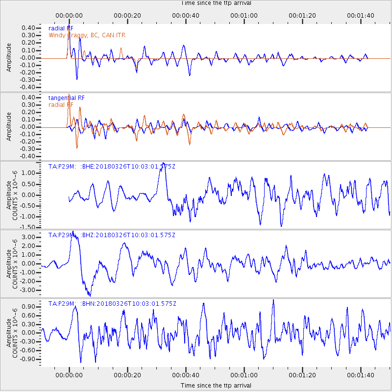
> Station P29M Windy Craggy, BC, CAN > Earthquake Result Viewer
P29M Windy Craggy, BC, CAN - Earthquake Result Viewer
| Earthquake location: |
New Britain Region, P.N.G. |
| Earthquake latitude/longitude: |
-5.5/151.4 |
| Earthquake time(UTC): |
2018/03/26 (085) 09:51:00 GMT |
| Earthquake Depth: |
40 km |
| Earthquake Magnitude: |
6.6 mww |
| Earthquake Catalog/Contributor: |
NEIC PDE/us |
|
| Network: |
TA USArray Transportable Network (new EarthScope stations) |
| Station: |
P29M Windy Craggy, BC, CAN |
| Lat/Lon: |
59.63 N/137.74 W |
| Elevation: |
679 m |
|
| Distance: |
85.2 deg |
| Az: |
28.8 deg |
| Baz: |
250.715 deg |
| Ray Param: |
0.0449038 |
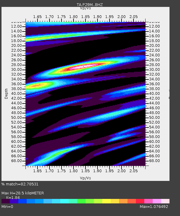
| Estimated Moho Depth: |
28.5 km |
| Estimated Crust Vp/Vs: |
1.84 |
| Assumed Crust Vp: |
6.566 km/s |
| Estimated Crust Vs: |
3.569 km/s |
| Estimated Crust Poisson's Ratio: |
0.29 |
|
| Radial Match: |
82.78531 % |
| Radial Bump: |
400 |
| Transverse Match: |
60.35746 % |
| Transverse Bump: |
400 |
| SOD ConfigId: |
13570011 |
| Insert Time: |
2019-04-30 00:41:05.051 +0000 |
| GWidth: |
2.5 |
| Max Bumps: |
400 |
| Tol: |
0.001 |
|
Signal To Noise
| Channel | StoN | STA | LTA |
| TA:P29M: :BHZ:20180326T10:03:01.575Z | 13.224965 | 2.393423E-6 | 1.8097764E-7 |
| TA:P29M: :BHN:20180326T10:03:01.575Z | 4.489741 | 5.8542764E-7 | 1.3039231E-7 |
| TA:P29M: :BHE:20180326T10:03:01.575Z | 2.9320455 | 8.7347763E-7 | 2.9790723E-7 |
| Arrivals |
| Ps | 3.7 SECOND |
| PpPs | 12 SECOND |
| PsPs/PpSs | 16 SECOND |


