You are here: Home > Network List > CO - South Carolina Seismic Network Stations List
> Station PAULI CO:PAULI > Earthquake Result Viewer
PAULI CO:PAULI - Earthquake Result Viewer
| Earthquake location: |
Northern East Pacific Rise |
| Earthquake latitude/longitude: |
10.3/-103.8 |
| Earthquake time(UTC): |
2016/04/29 (120) 01:33:38 GMT |
| Earthquake Depth: |
10 km |
| Earthquake Magnitude: |
6.8 MWP, 6.9 MI |
| Earthquake Catalog/Contributor: |
NEIC PDE/NEIC COMCAT |
|
| Network: |
CO South Carolina Seismic Network |
| Station: |
PAULI CO:PAULI |
| Lat/Lon: |
34.82 N/81.81 W |
| Elevation: |
179 m |
|
| Distance: |
31.6 deg |
| Az: |
35.916 deg |
| Baz: |
224.567 deg |
| Ray Param: |
0.07900169 |
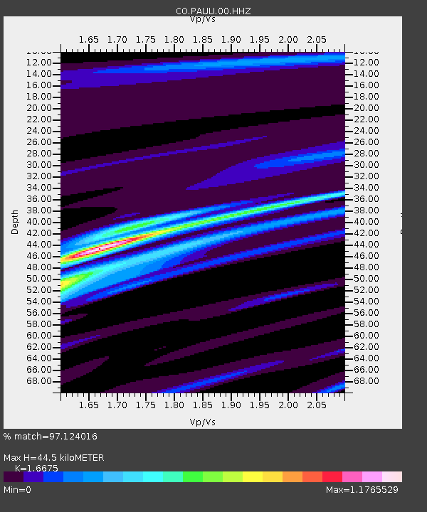
| Estimated Moho Depth: |
44.5 km |
| Estimated Crust Vp/Vs: |
1.67 |
| Assumed Crust Vp: |
6.419 km/s |
| Estimated Crust Vs: |
3.85 km/s |
| Estimated Crust Poisson's Ratio: |
0.22 |
|
| Radial Match: |
97.124016 % |
| Radial Bump: |
133 |
| Transverse Match: |
88.621635 % |
| Transverse Bump: |
400 |
| SOD ConfigId: |
1475611 |
| Insert Time: |
2016-05-13 01:34:50.929 +0000 |
| GWidth: |
2.5 |
| Max Bumps: |
400 |
| Tol: |
0.001 |
|

Signal To Noise
| Channel | StoN | STA | LTA |
| CO:PAULI:00:HHZ:20160429T01:39:31.08001Z | 21.279799 | 2.437377E-6 | 1.1453948E-7 |
| CO:PAULI:00:HHN:20160429T01:39:31.08001Z | 15.766056 | 1.1649172E-6 | 7.3887676E-8 |
| CO:PAULI:00:HHE:20160429T01:39:31.08001Z | 12.02932 | 1.0993867E-6 | 9.139226E-8 |
| Arrivals |
| Ps | 5.0 SECOND |
| PpPs | 17 SECOND |
| PsPs/PpSs | 22 SECOND |


