You are here: Home > Network List > TA - USArray Transportable Network (new EarthScope stations) Stations List
> Station Z25A Roswell, NM, USA > Earthquake Result Viewer
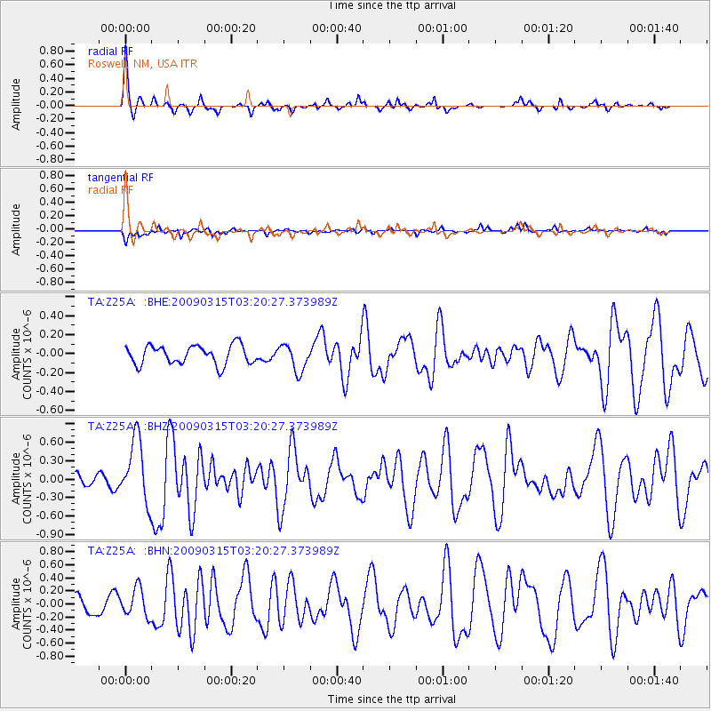
Z25A Roswell, NM, USA - Earthquake Result Viewer
*The percent match for this event was below the threshold and hence no stack was calculated.
| Earthquake location: |
Galapagos Islands Region |
| Earthquake latitude/longitude: |
2.4/-95.1 |
| Earthquake time(UTC): |
2009/03/15 (074) 03:14:31 GMT |
| Earthquake Depth: |
10 km |
| Earthquake Magnitude: |
5.5 MS, 5.4 MB, 5.8 MW, 5.8 MW |
| Earthquake Catalog/Contributor: |
WHDF/NEIC |
|
| Network: |
TA USArray Transportable Network (new EarthScope stations) |
| Station: |
Z25A Roswell, NM, USA |
| Lat/Lon: |
33.28 N/104.72 W |
| Elevation: |
1233 m |
|
| Distance: |
32.0 deg |
| Az: |
344.717 deg |
| Baz: |
161.677 deg |
| Ray Param: |
$rayparam |
*The percent match for this event was below the threshold and hence was not used in the summary stack. |
|
| Radial Match: |
76.099884 % |
| Radial Bump: |
275 |
| Transverse Match: |
43.07548 % |
| Transverse Bump: |
299 |
| SOD ConfigId: |
2658 |
| Insert Time: |
2010-03-06 10:05:31.633 +0000 |
| GWidth: |
2.5 |
| Max Bumps: |
400 |
| Tol: |
0.001 |
|
Signal To Noise
| Channel | StoN | STA | LTA |
| TA:Z25A: :BHZ:20090315T03:20:27.373989Z | 5.5886154 | 5.208815E-7 | 9.320404E-8 |
| TA:Z25A: :BHN:20090315T03:20:27.373989Z | 1.6191832 | 2.1696209E-7 | 1.3399477E-7 |
| TA:Z25A: :BHE:20090315T03:20:27.373989Z | 1.4336013 | 1.4247503E-7 | 9.93826E-8 |
| Arrivals |
| Ps | |
| PpPs | |
| PsPs/PpSs | |


