You are here: Home > Network List > GS - US Geological Survey Networks Stations List
> Station DEC09 Decatur Surface Seismic Site, Decatur, IL, USA > Earthquake Result Viewer
DEC09 Decatur Surface Seismic Site, Decatur, IL, USA - Earthquake Result Viewer

| Earthquake location: |
Northern East Pacific Rise |
| Earthquake latitude/longitude: |
10.3/-103.8 |
| Earthquake time(UTC): |
2016/04/29 (120) 01:33:38 GMT |
| Earthquake Depth: |
10 km |
| Earthquake Magnitude: |
6.8 MWP, 6.9 MI |
| Earthquake Catalog/Contributor: |
NEIC PDE/NEIC COMCAT |
|
| Network: |
GS US Geological Survey Networks |
| Station: |
DEC09 Decatur Surface Seismic Site, Decatur, IL, USA |
| Lat/Lon: |
39.87 N/88.92 W |
| Elevation: |
207 m |
|
| Distance: |
32.3 deg |
| Az: |
21.63 deg |
| Baz: |
208.128 deg |
| Ray Param: |
0.07870251 |
| Estimated Moho Depth: |
33.5 km |
| Estimated Crust Vp/Vs: |
2.09 |
| Assumed Crust Vp: |
6.444 km/s |
| Estimated Crust Vs: |
3.08 km/s |
| Estimated Crust Poisson's Ratio: |
0.35 |
|
| Radial Match: |
98.24085 % |
| Radial Bump: |
257 |
| Transverse Match: |
91.26187 % |
| Transverse Bump: |
400 |
| SOD ConfigId: |
1475611 |
| Insert Time: |
2016-05-13 01:36:12.423 +0000 |
| GWidth: |
2.5 |
| Max Bumps: |
400 |
| Tol: |
0.001 |
|
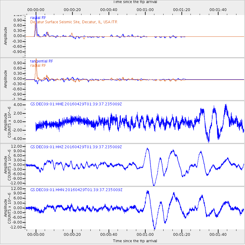
Signal To Noise
| Channel | StoN | STA | LTA |
| GS:DEC09:01:HHZ:20160429T01:39:37.235009Z | 9.644605 | 2.2017934E-6 | 2.2829276E-7 |
| GS:DEC09:01:HHN:20160429T01:39:37.235009Z | 3.116861 | 1.5769045E-6 | 5.059271E-7 |
| GS:DEC09:01:HHE:20160429T01:39:37.235009Z | 0.8088988 | 5.909382E-7 | 7.3054656E-7 |
| Arrivals |
| Ps | 6.1 SECOND |
| PpPs | 15 SECOND |
| PsPs/PpSs | 21 SECOND |


