You are here: Home > Network List > TA - USArray Transportable Network (new EarthScope stations) Stations List
> Station A21K Barrow, AK, USA > Earthquake Result Viewer
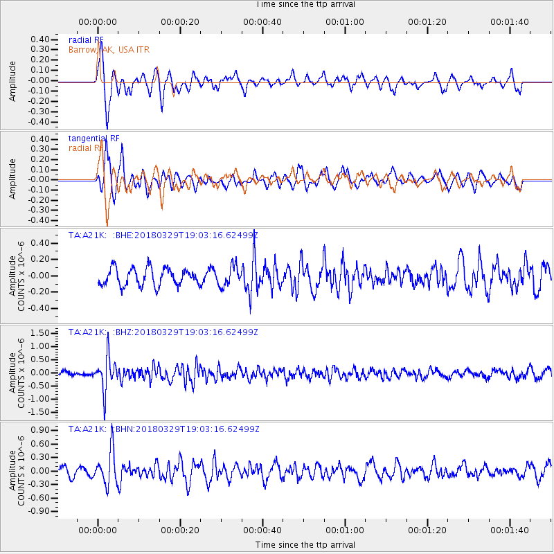
A21K Barrow, AK, USA - Earthquake Result Viewer
*The percent match for this event was below the threshold and hence no stack was calculated.
| Earthquake location: |
Solomon Islands |
| Earthquake latitude/longitude: |
-9.4/159.6 |
| Earthquake time(UTC): |
2018/03/29 (088) 18:51:09 GMT |
| Earthquake Depth: |
10 km |
| Earthquake Magnitude: |
5.8 Mww |
| Earthquake Catalog/Contributor: |
NEIC PDE/us |
|
| Network: |
TA USArray Transportable Network (new EarthScope stations) |
| Station: |
A21K Barrow, AK, USA |
| Lat/Lon: |
71.32 N/156.62 W |
| Elevation: |
577 m |
|
| Distance: |
85.7 deg |
| Az: |
12.928 deg |
| Baz: |
223.248 deg |
| Ray Param: |
$rayparam |
*The percent match for this event was below the threshold and hence was not used in the summary stack. |
|
| Radial Match: |
73.11169 % |
| Radial Bump: |
400 |
| Transverse Match: |
75.73025 % |
| Transverse Bump: |
374 |
| SOD ConfigId: |
13570011 |
| Insert Time: |
2019-04-30 00:48:19.161 +0000 |
| GWidth: |
2.5 |
| Max Bumps: |
400 |
| Tol: |
0.001 |
|
Signal To Noise
| Channel | StoN | STA | LTA |
| TA:A21K: :BHZ:20180329T19:03:16.62499Z | 5.2529535 | 6.521782E-7 | 1.2415458E-7 |
| TA:A21K: :BHN:20180329T19:03:16.62499Z | 3.4234889 | 3.910988E-7 | 1.1423983E-7 |
| TA:A21K: :BHE:20180329T19:03:16.62499Z | 1.1908008 | 1.2451622E-7 | 1.0456511E-7 |
| Arrivals |
| Ps | |
| PpPs | |
| PsPs/PpSs | |


