You are here: Home > Network List > TA - USArray Transportable Network (new EarthScope stations) Stations List
> Station Y25A Mesa, Roswell, NM, USA > Earthquake Result Viewer
Y25A Mesa, Roswell, NM, USA - Earthquake Result Viewer
| Earthquake location: |
Tonga Islands |
| Earthquake latitude/longitude: |
-21.9/-173.8 |
| Earthquake time(UTC): |
2008/10/19 (293) 05:10:33 GMT |
| Earthquake Depth: |
29 km |
| Earthquake Magnitude: |
6.8 MB, 7.0 MS, 6.9 MW, 6.9 MW |
| Earthquake Catalog/Contributor: |
WHDF/NEIC |
|
| Network: |
TA USArray Transportable Network (new EarthScope stations) |
| Station: |
Y25A Mesa, Roswell, NM, USA |
| Lat/Lon: |
33.92 N/104.69 W |
| Elevation: |
1364 m |
|
| Distance: |
86.0 deg |
| Az: |
51.154 deg |
| Baz: |
240.467 deg |
| Ray Param: |
0.044320237 |
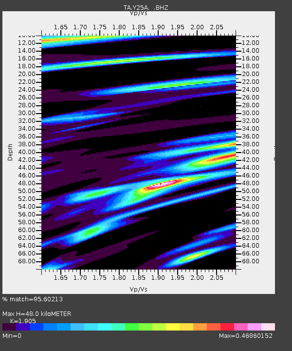
| Estimated Moho Depth: |
48.0 km |
| Estimated Crust Vp/Vs: |
1.90 |
| Assumed Crust Vp: |
6.232 km/s |
| Estimated Crust Vs: |
3.271 km/s |
| Estimated Crust Poisson's Ratio: |
0.31 |
|
| Radial Match: |
95.60213 % |
| Radial Bump: |
326 |
| Transverse Match: |
94.30279 % |
| Transverse Bump: |
382 |
| SOD ConfigId: |
2556 |
| Insert Time: |
2010-03-06 10:06:37.889 +0000 |
| GWidth: |
2.5 |
| Max Bumps: |
400 |
| Tol: |
0.001 |
|
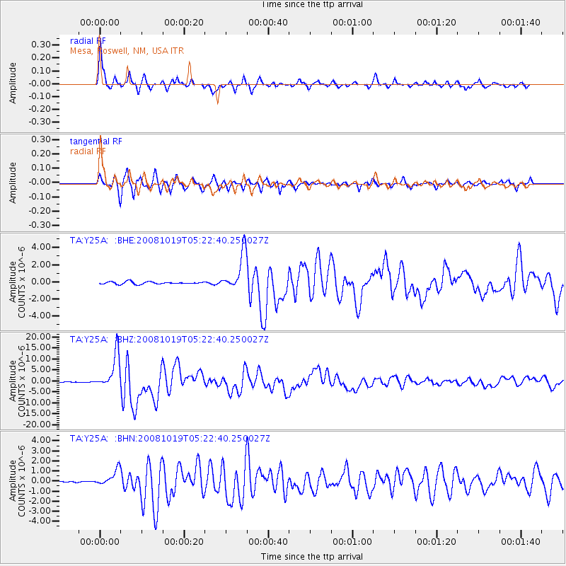
Signal To Noise
| Channel | StoN | STA | LTA |
| TA:Y25A: :BHZ:20081019T05:22:40.250027Z | 58.913834 | 8.066569E-6 | 1.3692147E-7 |
| TA:Y25A: :BHN:20081019T05:22:40.250027Z | 8.758393 | 8.091902E-7 | 9.239026E-8 |
| TA:Y25A: :BHE:20081019T05:22:40.250027Z | 16.743702 | 2.2880026E-6 | 1.3664855E-7 |
| Arrivals |
| Ps | 7.1 SECOND |
| PpPs | 22 SECOND |
| PsPs/PpSs | 29 SECOND |


