You are here: Home > Network List > TA - USArray Transportable Network (new EarthScope stations) Stations List
> Station F20K Avaraart Lake, AK, USA > Earthquake Result Viewer
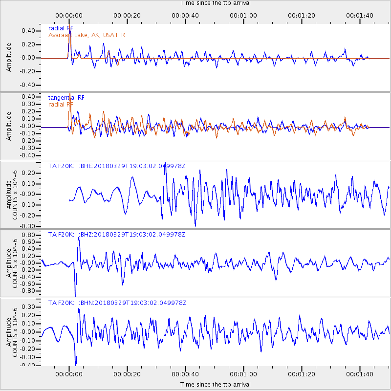
F20K Avaraart Lake, AK, USA - Earthquake Result Viewer
*The percent match for this event was below the threshold and hence no stack was calculated.
| Earthquake location: |
Solomon Islands |
| Earthquake latitude/longitude: |
-9.4/159.6 |
| Earthquake time(UTC): |
2018/03/29 (088) 18:51:09 GMT |
| Earthquake Depth: |
10 km |
| Earthquake Magnitude: |
5.8 Mww |
| Earthquake Catalog/Contributor: |
NEIC PDE/us |
|
| Network: |
TA USArray Transportable Network (new EarthScope stations) |
| Station: |
F20K Avaraart Lake, AK, USA |
| Lat/Lon: |
67.05 N/155.73 W |
| Elevation: |
136 m |
|
| Distance: |
82.8 deg |
| Az: |
16.148 deg |
| Baz: |
224.406 deg |
| Ray Param: |
$rayparam |
*The percent match for this event was below the threshold and hence was not used in the summary stack. |
|
| Radial Match: |
71.71043 % |
| Radial Bump: |
400 |
| Transverse Match: |
53.086273 % |
| Transverse Bump: |
400 |
| SOD ConfigId: |
13570011 |
| Insert Time: |
2019-04-30 00:48:49.779 +0000 |
| GWidth: |
2.5 |
| Max Bumps: |
400 |
| Tol: |
0.001 |
|
Signal To Noise
| Channel | StoN | STA | LTA |
| TA:F20K: :BHZ:20180329T19:03:02.049978Z | 5.620838 | 3.621416E-7 | 6.44284E-8 |
| TA:F20K: :BHN:20180329T19:03:02.049978Z | 2.8882418 | 1.635924E-7 | 5.6640825E-8 |
| TA:F20K: :BHE:20180329T19:03:02.049978Z | 1.7970788 | 1.2254415E-7 | 6.8190744E-8 |
| Arrivals |
| Ps | |
| PpPs | |
| PsPs/PpSs | |


