You are here: Home > Network List > TA - USArray Transportable Network (new EarthScope stations) Stations List
> Station Y25A Mesa, Roswell, NM, USA > Earthquake Result Viewer
Y25A Mesa, Roswell, NM, USA - Earthquake Result Viewer
| Earthquake location: |
Colombia |
| Earthquake latitude/longitude: |
4.8/-75.5 |
| Earthquake time(UTC): |
2008/09/13 (257) 09:32:01 GMT |
| Earthquake Depth: |
133 km |
| Earthquake Magnitude: |
5.9 MB, 5.7 MW, 5.7 MW |
| Earthquake Catalog/Contributor: |
WHDF/NEIC |
|
| Network: |
TA USArray Transportable Network (new EarthScope stations) |
| Station: |
Y25A Mesa, Roswell, NM, USA |
| Lat/Lon: |
33.92 N/104.69 W |
| Elevation: |
1364 m |
|
| Distance: |
39.7 deg |
| Az: |
320.593 deg |
| Baz: |
130.463 deg |
| Ray Param: |
0.07437692 |
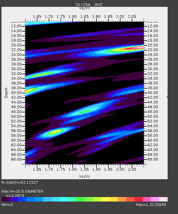
| Estimated Moho Depth: |
20.5 km |
| Estimated Crust Vp/Vs: |
2.10 |
| Assumed Crust Vp: |
6.232 km/s |
| Estimated Crust Vs: |
2.971 km/s |
| Estimated Crust Poisson's Ratio: |
0.35 |
|
| Radial Match: |
83.11527 % |
| Radial Bump: |
286 |
| Transverse Match: |
59.876842 % |
| Transverse Bump: |
290 |
| SOD ConfigId: |
2560 |
| Insert Time: |
2010-03-06 10:06:47.449 +0000 |
| GWidth: |
2.5 |
| Max Bumps: |
400 |
| Tol: |
0.001 |
|
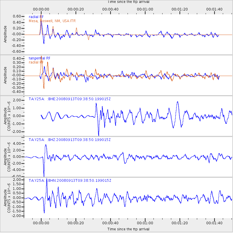
Signal To Noise
| Channel | StoN | STA | LTA |
| TA:Y25A: :BHZ:20080913T09:38:50.199015Z | 6.092458 | 2.1520086E-6 | 3.5322503E-7 |
| TA:Y25A: :BHN:20080913T09:38:50.199015Z | 2.642158 | 7.5472195E-7 | 2.8564602E-7 |
| TA:Y25A: :BHE:20080913T09:38:50.199015Z | 3.657271 | 8.979881E-7 | 2.4553503E-7 |
| Arrivals |
| Ps | 3.8 SECOND |
| PpPs | 9.6 SECOND |
| PsPs/PpSs | 13 SECOND |


