You are here: Home > Network List > TA - USArray Transportable Network (new EarthScope stations) Stations List
> Station Y25A Mesa, Roswell, NM, USA > Earthquake Result Viewer
Y25A Mesa, Roswell, NM, USA - Earthquake Result Viewer
| Earthquake location: |
Kermadec Islands Region |
| Earthquake latitude/longitude: |
-27.4/-176.3 |
| Earthquake time(UTC): |
2009/02/18 (049) 21:53:45 GMT |
| Earthquake Depth: |
25 km |
| Earthquake Magnitude: |
6.8 MB, 7.2 MS, 6.9 MW, 6.9 MW |
| Earthquake Catalog/Contributor: |
WHDF/NEIC |
|
| Network: |
TA USArray Transportable Network (new EarthScope stations) |
| Station: |
Y25A Mesa, Roswell, NM, USA |
| Lat/Lon: |
33.92 N/104.69 W |
| Elevation: |
1364 m |
|
| Distance: |
91.2 deg |
| Az: |
52.126 deg |
| Baz: |
237.546 deg |
| Ray Param: |
0.04161364 |
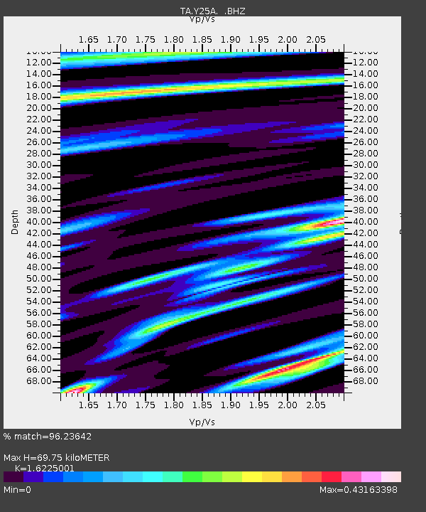
| Estimated Moho Depth: |
69.75 km |
| Estimated Crust Vp/Vs: |
1.62 |
| Assumed Crust Vp: |
6.232 km/s |
| Estimated Crust Vs: |
3.841 km/s |
| Estimated Crust Poisson's Ratio: |
0.19 |
|
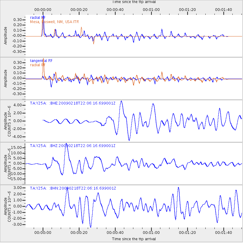
| Radial Match: |
96.23642 % |
| Radial Bump: |
331 |
| Transverse Match: |
89.45547 % |
| Transverse Bump: |
377 |
| SOD ConfigId: |
2658 |
| Insert Time: |
2010-03-06 10:07:00.458 +0000 |
| GWidth: |
2.5 |
| Max Bumps: |
400 |
| Tol: |
0.001 |
|
Signal To Noise
| Channel | StoN | STA | LTA |
| TA:Y25A: :BHZ:20090218T22:06:16.699001Z | 4.854448 | 2.267607E-6 | 4.6711943E-7 |
| TA:Y25A: :BHN:20090218T22:06:16.699001Z | 2.0560515 | 3.4898596E-7 | 1.69736E-7 |
| TA:Y25A: :BHE:20090218T22:06:16.699001Z | 1.8483462 | 6.1503795E-7 | 3.327504E-7 |
| Arrivals |
| Ps | 7.1 SECOND |
| PpPs | 29 SECOND |
| PsPs/PpSs | 36 SECOND |


