You are here: Home > Network List > TA - USArray Transportable Network (new EarthScope stations) Stations List
> Station Y25A Mesa, Roswell, NM, USA > Earthquake Result Viewer
Y25A Mesa, Roswell, NM, USA - Earthquake Result Viewer
| Earthquake location: |
Santa Cruz Islands |
| Earthquake latitude/longitude: |
-11.6/166.1 |
| Earthquake time(UTC): |
2009/08/10 (222) 04:06:31 GMT |
| Earthquake Depth: |
35 km |
| Earthquake Magnitude: |
5.8 MB, 6.3 MS, 6.6 MW, 6.6 MW |
| Earthquake Catalog/Contributor: |
WHDF/NEIC |
|
| Network: |
TA USArray Transportable Network (new EarthScope stations) |
| Station: |
Y25A Mesa, Roswell, NM, USA |
| Lat/Lon: |
33.92 N/104.69 W |
| Elevation: |
1364 m |
|
| Distance: |
95.7 deg |
| Az: |
56.681 deg |
| Baz: |
259.944 deg |
| Ray Param: |
0.040687185 |
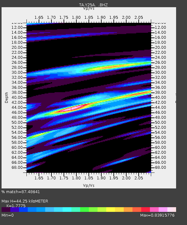
| Estimated Moho Depth: |
44.25 km |
| Estimated Crust Vp/Vs: |
1.78 |
| Assumed Crust Vp: |
6.232 km/s |
| Estimated Crust Vs: |
3.506 km/s |
| Estimated Crust Poisson's Ratio: |
0.27 |
|
| Radial Match: |
87.48641 % |
| Radial Bump: |
400 |
| Transverse Match: |
59.535885 % |
| Transverse Bump: |
400 |
| SOD ConfigId: |
2622 |
| Insert Time: |
2010-03-06 10:07:06.718 +0000 |
| GWidth: |
2.5 |
| Max Bumps: |
400 |
| Tol: |
0.001 |
|

Signal To Noise
| Channel | StoN | STA | LTA |
| TA:Y25A: :BHZ:20090810T04:19:21.924011Z | 5.726448 | 3.4318356E-7 | 5.992957E-8 |
| TA:Y25A: :BHN:20090810T04:19:21.924011Z | 0.6345234 | 4.5373014E-8 | 7.150724E-8 |
| TA:Y25A: :BHE:20090810T04:19:21.924011Z | 2.225277 | 1.1097894E-7 | 4.9871968E-8 |
| Arrivals |
| Ps | 5.6 SECOND |
| PpPs | 19 SECOND |
| PsPs/PpSs | 25 SECOND |


