You are here: Home > Network List > TA - USArray Transportable Network (new EarthScope stations) Stations List
> Station Y25A Mesa, Roswell, NM, USA > Earthquake Result Viewer
Y25A Mesa, Roswell, NM, USA - Earthquake Result Viewer
| Earthquake location: |
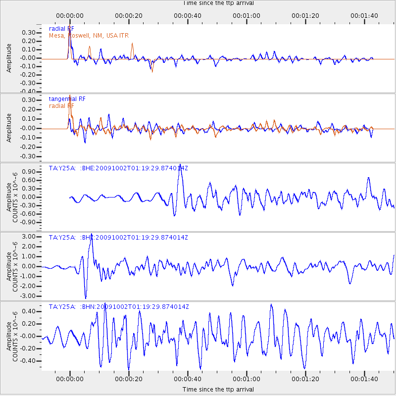
Tonga Islands |
| Earthquake latitude/longitude: |
-16.3/-173.5 |
| Earthquake time(UTC): |
2009/10/02 (275) 01:07:39 GMT |
| Earthquake Depth: |
8.0 km |
| Earthquake Magnitude: |
6.1 MB, 6.0 MS, 6.1 MW, 6.1 MW |
| Earthquake Catalog/Contributor: |
WHDF/NEIC |
|
| Network: |
TA USArray Transportable Network (new EarthScope stations) |
| Station: |
Y25A Mesa, Roswell, NM, USA |
| Lat/Lon: |
33.92 N/104.69 W |
| Elevation: |
1364 m |
|
| Distance: |
82.3 deg |
| Az: |
51.458 deg |
| Baz: |
244.574 deg |
| Ray Param: |
0.046975967 |
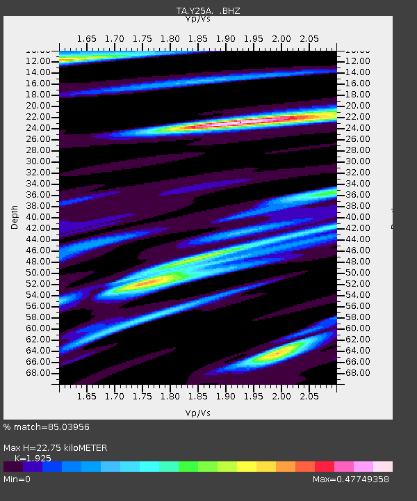
| Estimated Moho Depth: |
22.75 km |
| Estimated Crust Vp/Vs: |
1.92 |
| Assumed Crust Vp: |
6.232 km/s |
| Estimated Crust Vs: |
3.237 km/s |
| Estimated Crust Poisson's Ratio: |
0.32 |
|
| Radial Match: |
85.03956 % |
| Radial Bump: |
384 |
| Transverse Match: |
80.337105 % |
| Transverse Bump: |
400 |
| SOD ConfigId: |
2622 |
| Insert Time: |
2010-03-06 10:07:21.998 +0000 |
| GWidth: |
2.5 |
| Max Bumps: |
400 |
| Tol: |
0.001 |
|
Signal To Noise
| Channel | StoN | STA | LTA |
| TA:Y25A: :BHZ:20091002T01:19:29.874014Z | 6.5987325 | 4.7534905E-7 | 7.203642E-8 |
| TA:Y25A: :BHN:20091002T01:19:29.874014Z | 0.46389088 | 7.1721956E-8 | 1.5460954E-7 |
| TA:Y25A: :BHE:20091002T01:19:29.874014Z | 1.7760526 | 1.5262195E-7 | 8.593324E-8 |
| Arrivals |
| Ps | 3.5 SECOND |
| PpPs | 10 SECOND |
| PsPs/PpSs | 14 SECOND |


