You are here: Home > Network List > TA - USArray Transportable Network (new EarthScope stations) Stations List
> Station Y25A Mesa, Roswell, NM, USA > Earthquake Result Viewer
Y25A Mesa, Roswell, NM, USA - Earthquake Result Viewer
| Earthquake location: |
Kermadec Islands Region |
| Earthquake latitude/longitude: |
-31.2/-176.9 |
| Earthquake time(UTC): |
2008/12/09 (344) 06:23:59 GMT |
| Earthquake Depth: |
18 km |
| Earthquake Magnitude: |
6.2 MB, 6.7 MS, 6.8 MW, 6.7 MW |
| Earthquake Catalog/Contributor: |
WHDF/NEIC |
|
| Network: |
TA USArray Transportable Network (new EarthScope stations) |
| Station: |
Y25A Mesa, Roswell, NM, USA |
| Lat/Lon: |
33.92 N/104.69 W |
| Elevation: |
1364 m |
|
| Distance: |
94.0 deg |
| Az: |
52.538 deg |
| Baz: |
234.856 deg |
| Ray Param: |
0.04114799 |
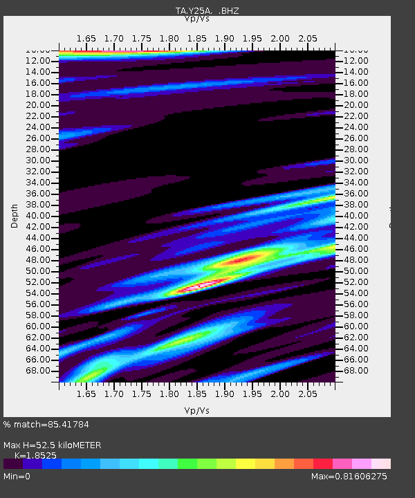
| Estimated Moho Depth: |
52.5 km |
| Estimated Crust Vp/Vs: |
1.85 |
| Assumed Crust Vp: |
6.232 km/s |
| Estimated Crust Vs: |
3.364 km/s |
| Estimated Crust Poisson's Ratio: |
0.29 |
|
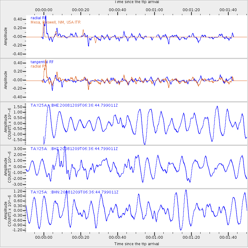
| Radial Match: |
85.41784 % |
| Radial Bump: |
400 |
| Transverse Match: |
51.129494 % |
| Transverse Bump: |
396 |
| SOD ConfigId: |
2658 |
| Insert Time: |
2010-03-06 10:07:35.254 +0000 |
| GWidth: |
2.5 |
| Max Bumps: |
400 |
| Tol: |
0.001 |
|
Signal To Noise
| Channel | StoN | STA | LTA |
| TA:Y25A: :BHZ:20081209T06:36:44.799011Z | 2.0557141 | 1.2839157E-6 | 6.245595E-7 |
| TA:Y25A: :BHN:20081209T06:36:44.799011Z | 1.615114 | 6.3763395E-7 | 3.947919E-7 |
| TA:Y25A: :BHE:20081209T06:36:44.799011Z | 0.6587975 | 4.8167755E-7 | 7.3114654E-7 |
| Arrivals |
| Ps | 7.3 SECOND |
| PpPs | 24 SECOND |
| PsPs/PpSs | 31 SECOND |


