You are here: Home > Network List > TA - USArray Transportable Network (new EarthScope stations) Stations List
> Station Y25A Mesa, Roswell, NM, USA > Earthquake Result Viewer
Y25A Mesa, Roswell, NM, USA - Earthquake Result Viewer
| Earthquake location: |
Kodiak Island Region, Alaska |
| Earthquake latitude/longitude: |
56.5/-152.7 |
| Earthquake time(UTC): |
2009/03/30 (089) 07:13:07 GMT |
| Earthquake Depth: |
21 km |
| Earthquake Magnitude: |
5.9 MB, 5.9 MS, 5.9 MW, 5.9 MW |
| Earthquake Catalog/Contributor: |
WHDF/NEIC |
|
| Network: |
TA USArray Transportable Network (new EarthScope stations) |
| Station: |
Y25A Mesa, Roswell, NM, USA |
| Lat/Lon: |
33.92 N/104.69 W |
| Elevation: |
1364 m |
|
| Distance: |
39.6 deg |
| Az: |
104.084 deg |
| Baz: |
319.756 deg |
| Ray Param: |
0.07485537 |
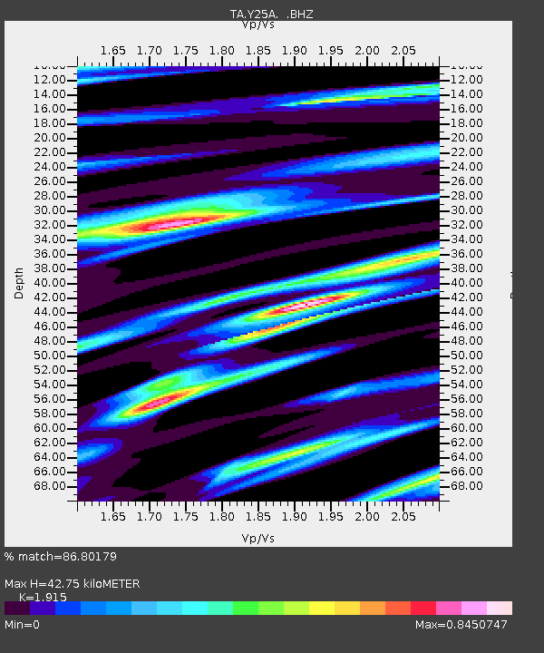
| Estimated Moho Depth: |
42.75 km |
| Estimated Crust Vp/Vs: |
1.91 |
| Assumed Crust Vp: |
6.232 km/s |
| Estimated Crust Vs: |
3.254 km/s |
| Estimated Crust Poisson's Ratio: |
0.31 |
|
| Radial Match: |
86.80179 % |
| Radial Bump: |
400 |
| Transverse Match: |
62.025425 % |
| Transverse Bump: |
385 |
| SOD ConfigId: |
2658 |
| Insert Time: |
2010-03-06 10:07:47.741 +0000 |
| GWidth: |
2.5 |
| Max Bumps: |
400 |
| Tol: |
0.001 |
|
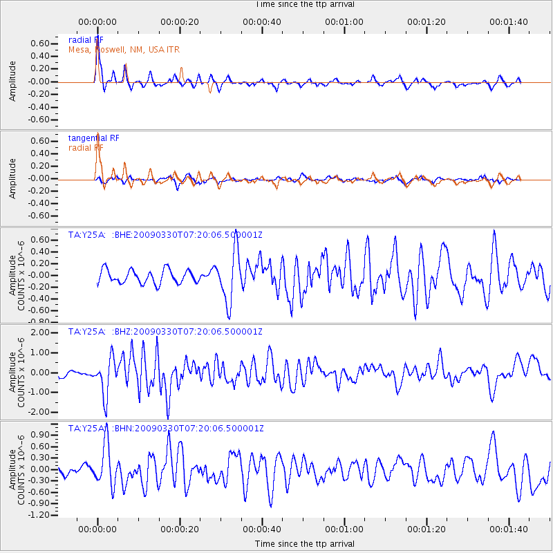
Signal To Noise
| Channel | StoN | STA | LTA |
| TA:Y25A: :BHZ:20090330T07:20:06.500001Z | 5.3639507 | 9.5353244E-7 | 1.7776682E-7 |
| TA:Y25A: :BHN:20090330T07:20:06.500001Z | 4.586163 | 5.569057E-7 | 1.2143174E-7 |
| TA:Y25A: :BHE:20090330T07:20:06.500001Z | 3.9177725 | 4.468526E-7 | 1.1405782E-7 |
| Arrivals |
| Ps | 6.7 SECOND |
| PpPs | 19 SECOND |
| PsPs/PpSs | 25 SECOND |


