You are here: Home > Network List > AE - Arizona Broadband Seismic Network Stations List
> Station U15A North Rim, AZ, USA > Earthquake Result Viewer
U15A North Rim, AZ, USA - Earthquake Result Viewer
| Earthquake location: |
New Britain Region, P.N.G. |
| Earthquake latitude/longitude: |
-5.5/151.4 |
| Earthquake time(UTC): |
2018/03/29 (088) 21:25:32 GMT |
| Earthquake Depth: |
10 km |
| Earthquake Magnitude: |
6.9 mww |
| Earthquake Catalog/Contributor: |
NEIC PDE/us |
|
| Network: |
AE Arizona Broadband Seismic Network |
| Station: |
U15A North Rim, AZ, USA |
| Lat/Lon: |
36.43 N/112.29 W |
| Elevation: |
2489 m |
|
| Distance: |
98.3 deg |
| Az: |
54.104 deg |
| Baz: |
269.291 deg |
| Ray Param: |
0.039960016 |
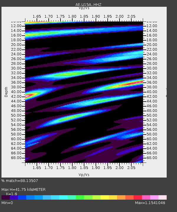
| Estimated Moho Depth: |
41.75 km |
| Estimated Crust Vp/Vs: |
1.60 |
| Assumed Crust Vp: |
6.194 km/s |
| Estimated Crust Vs: |
3.871 km/s |
| Estimated Crust Poisson's Ratio: |
0.18 |
|
| Radial Match: |
88.13507 % |
| Radial Bump: |
400 |
| Transverse Match: |
79.17343 % |
| Transverse Bump: |
400 |
| SOD ConfigId: |
13570011 |
| Insert Time: |
2019-04-30 00:51:46.894 +0000 |
| GWidth: |
2.5 |
| Max Bumps: |
400 |
| Tol: |
0.001 |
|

Signal To Noise
| Channel | StoN | STA | LTA |
| AE:U15A: :HHZ:20180329T21:38:38.898979Z | 7.6296277 | 8.12764E-7 | 1.0652734E-7 |
| AE:U15A: :HHN:20180329T21:38:38.898979Z | 0.4519655 | 3.5078717E-8 | 7.76137E-8 |
| AE:U15A: :HHE:20180329T21:38:38.898979Z | 2.8499022 | 3.1444353E-7 | 1.1033485E-7 |
| Arrivals |
| Ps | 4.1 SECOND |
| PpPs | 17 SECOND |
| PsPs/PpSs | 21 SECOND |


