You are here: Home > Network List > TA - USArray Transportable Network (new EarthScope stations) Stations List
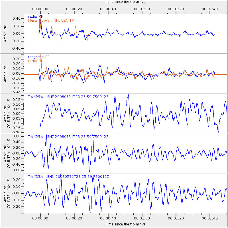
> Station Y25A Mesa, Roswell, NM, USA > Earthquake Result Viewer
Y25A Mesa, Roswell, NM, USA - Earthquake Result Viewer
| Earthquake location: |
Easter Island Region |
| Earthquake latitude/longitude: |
-28.9/-112.3 |
| Earthquake time(UTC): |
2008/05/31 (152) 23:16:04 GMT |
| Earthquake Depth: |
10 km |
| Earthquake Magnitude: |
5.5 MS, 5.4 MB, 5.8 MW, 5.8 MW |
| Earthquake Catalog/Contributor: |
WHDF/NEIC |
|
| Network: |
TA USArray Transportable Network (new EarthScope stations) |
| Station: |
Y25A Mesa, Roswell, NM, USA |
| Lat/Lon: |
33.92 N/104.69 W |
| Elevation: |
1364 m |
|
| Distance: |
62.9 deg |
| Az: |
7.063 deg |
| Baz: |
187.449 deg |
| Ray Param: |
0.05991863 |
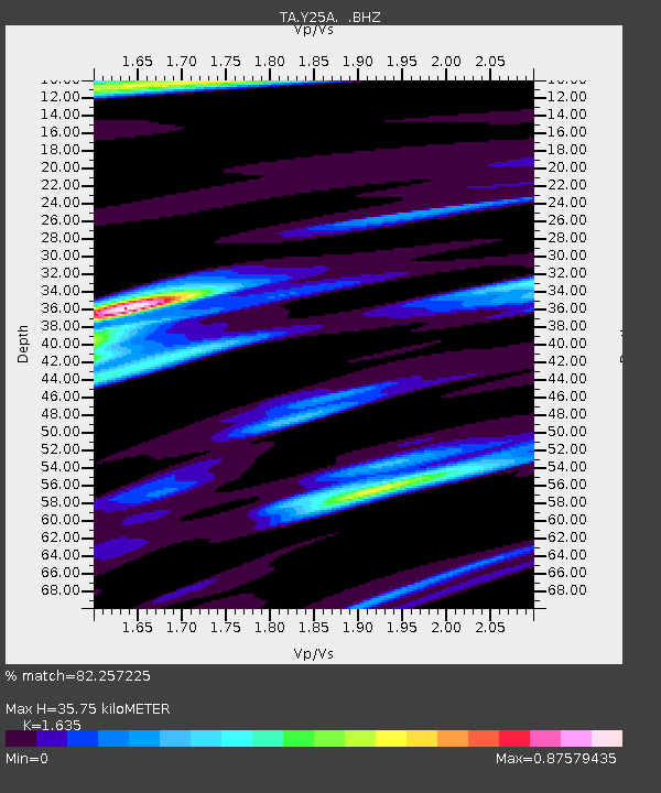
| Estimated Moho Depth: |
35.75 km |
| Estimated Crust Vp/Vs: |
1.63 |
| Assumed Crust Vp: |
6.232 km/s |
| Estimated Crust Vs: |
3.811 km/s |
| Estimated Crust Poisson's Ratio: |
0.20 |
|
| Radial Match: |
82.257225 % |
| Radial Bump: |
400 |
| Transverse Match: |
62.052174 % |
| Transverse Bump: |
400 |
| SOD ConfigId: |
2504 |
| Insert Time: |
2010-03-06 10:08:04.393 +0000 |
| GWidth: |
2.5 |
| Max Bumps: |
400 |
| Tol: |
0.001 |
|
Signal To Noise
| Channel | StoN | STA | LTA |
| TA:Y25A: :BHZ:20080531T23:25:59.750012Z | 7.7875752 | 3.2652642E-7 | 4.192915E-8 |
| TA:Y25A: :BHN:20080531T23:25:59.750012Z | 2.6712663 | 9.594895E-8 | 3.59189E-8 |
| TA:Y25A: :BHE:20080531T23:25:59.750012Z | 0.9018781 | 4.995794E-8 | 5.5393226E-8 |
| Arrivals |
| Ps | 3.8 SECOND |
| PpPs | 14 SECOND |
| PsPs/PpSs | 18 SECOND |


